IMAGES TAKEN NEAR TO
Waterloo Road, CLITHEROE, BB7 1LR
Introduction
This page details the photographs taken nearby to Waterloo Road, BB7 1LR by members of the Geograph project.
The Geograph project started in 2005 with the aim of publishing, organising and preserving representative images for every square kilometre of Great Britain, Ireland and the Isle of Man.

There are currently over 7.5m images from over14,400 individuals and you can help contribute to the project by visiting https://www.geograph.org.uk
Image Map
Images are licensed for reuse under creativecommons.org/licenses/by-sa/2.0
Notes
- Clicking on the map will re-center to the selected point.
- The higher the marker number, the further away the image location is from the centre of the postcode.
Image Listing (472 Images Found)
Images are licensed for reuse under creativecommons.org/licenses/by-sa/2.0
Image
Details
Distance
2
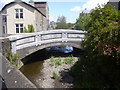
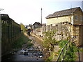
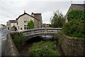
Waterloo Bridge 1925 over Mearley Brook
Image: © Robert Wade
Taken: 11 Jun 2009
0.02 miles
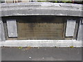
3
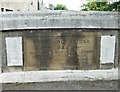
Old Boundary Marker
Bridge Marker carved in north bridge parapet of Waterloo Bridge, Marley Brook. CLITHEROE parish. Inscribed WATERLOO BRIDGE / 1925. See also https://www.geograph.org.uk/photo/1351045.
Milestone Society National ID: LA_CLITH01br
Image: © M Bardell
Taken: 7 Jul 2019
0.02 miles
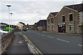
6
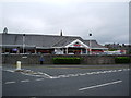
Every little helps ( with our huge profits)
Tesco Supermarket
Image: © Alexander P Kapp
Taken: 24 Apr 2007
0.03 miles
7
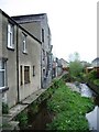
Mearley Brook passing under Holden Street, Clitheroe
Image: © Alexander P Kapp
Taken: 21 Sep 2012
0.03 miles