
IMAGES TAKEN NEAR TO
Pendle Road, CLITHEROE, BB7 1JH
Introduction
This page details the photographs taken nearby to Pendle Road, BB7 1JH by members of the Geograph project.
The Geograph project started in 2005 with the aim of publishing, organising and preserving representative images for every square kilometre of Great Britain, Ireland and the Isle of Man.

There are currently over 7.5m images from over14,400 individuals and you can help contribute to the project by visiting https://www.geograph.org.uk
Image Map
Images are licensed for reuse under creativecommons.org/licenses/by-sa/2.0
Notes
- Clicking on the map will re-center to the selected point.
- The higher the marker number, the further away the image location is from the centre of the postcode.
Image Listing (5 Images Found)
Images are licensed for reuse under creativecommons.org/licenses/by-sa/2.0
Image
Details
Distance
1
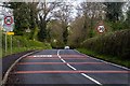
Pendle Road
Pendle Road entering Clitheroe.
Image: © Peter McDermott
Taken: 4 May 2015
0.13 miles
2
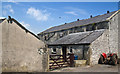
Clitheroe Grammar School 1860
The origins of Clitheroe Grammar School go back to the sixteenth century. In one of its incarnations it appears to have occupied this building which is now a farm
Image: © Ian Greig
Taken: 18 Jul 2014
0.16 miles
3
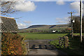
Across The Fields
Across the fields and onwards we go eventually we will arrive at Dunham Village
Image: © Alan James
Taken: 7 Nov 2010
0.16 miles
4
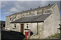
The Old School
Clitheroe Grammar School 1860 what a nice find I was looking for any unusual building to photograph what better than the old grammar school.
Image: © Alan James
Taken: 9 Nov 2010
0.17 miles
5
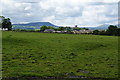
A field on the edge of Clitheroe
Beyond this field, which has cows in it, you can see Clitheroe Castle framed by Kemple End and Parlick.
Image: © Bill Boaden
Taken: 11 Jun 2011
0.23 miles