IMAGES TAKEN NEAR TO
Lingfield Avenue, CLITHEROE, BB7 1HA
Introduction
This page details the photographs taken nearby to Lingfield Avenue, BB7 1HA by members of the Geograph project.
The Geograph project started in 2005 with the aim of publishing, organising and preserving representative images for every square kilometre of Great Britain, Ireland and the Isle of Man.

There are currently over 7.5m images from over14,400 individuals and you can help contribute to the project by visiting https://www.geograph.org.uk
Image Map
Images are licensed for reuse under creativecommons.org/licenses/by-sa/2.0
Notes
- Clicking on the map will re-center to the selected point.
- The higher the marker number, the further away the image location is from the centre of the postcode.
Image Listing (11 Images Found)
Images are licensed for reuse under creativecommons.org/licenses/by-sa/2.0
Image
Details
Distance
1
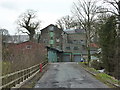
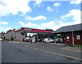
Littlemoor Mill, Clitheroe
Former flour mill now used as a plant hire depot
Image: © Alexander P Kapp
Taken: 12 Mar 2011
0.18 miles
3
What was Barker's Nursery
A nursery of long standing, until a few years ago
Image: © Alexander P Kapp
Taken: 17 May 2008
0.23 miles
4
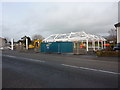
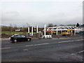
New petrol filling station
Being built on the site of what was Primrose Garage
Image: © Alexander P Kapp
Taken: 31 Mar 2010
0.23 miles
5
New petrol filling station
Being built on the site of what was Primrose Garage
Image: © Alexander P Kapp
Taken: 31 Mar 2010
0.24 miles
6
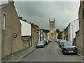
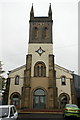
St James Street and church, Clitheroe
The church, listed grade II (entry 1072358) dates from 1839-42 and is a classic 'Commissioners church'.
Image: © Stephen Craven
Taken: 23 Aug 2022
0.24 miles
7
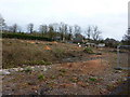
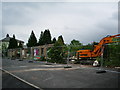
Formerly Primrose Garden Centre
The tree etc had been allowed to grow for a few years and it was becoming, nature reserve?, but it looks as if the decision to build has been made or is becoming nearer.
Image: © Alexander P Kapp
Taken: 31 Mar 2010
0.24 miles
9
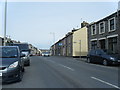
Whalley Road with Park Street on the right.
Image: © Colin Pyle
Taken: 23 Mar 2010
0.25 miles
10
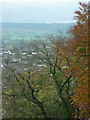
The Nick of Pendle
Taken from the western section of the curtain wall at Clitheroe Castle, Clitheroe, Lancashire, I am looking south east to the Nick of Pendle.
Image: © Carroll Pierce
Taken: 5 Nov 2015
0.25 miles