IMAGES TAKEN NEAR TO
Pendle View, BLACKBURN, BB6 8AT
Introduction
This page details the photographs taken nearby to Pendle View, BB6 8AT by members of the Geograph project.
The Geograph project started in 2005 with the aim of publishing, organising and preserving representative images for every square kilometre of Great Britain, Ireland and the Isle of Man.

There are currently over 7.5m images from over14,400 individuals and you can help contribute to the project by visiting https://www.geograph.org.uk
Image Map
Images are licensed for reuse under creativecommons.org/licenses/by-sa/2.0
Notes
- Clicking on the map will re-center to the selected point.
- The higher the marker number, the further away the image location is from the centre of the postcode.
Image Listing (8 Images Found)
Images are licensed for reuse under creativecommons.org/licenses/by-sa/2.0
Image
Details
Distance
1
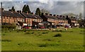
Brockhall Village
Houses on the edge of Brockhall Village.
Image: © Peter McDermott
Taken: 4 May 2015
0.05 miles
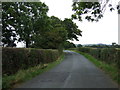
4
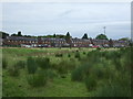
Rough grazing towards Brookhall Village
Off Old Langho Road.
Image: © JThomas
Taken: 24 Sep 2016
0.17 miles
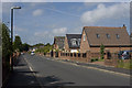
5
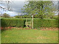
Footpath from Larkhill Cottages
The stile for the footpath at Larkhill Cottages leading across the fields towards Hacking Hall.
Image: © Steve Houldsworth
Taken: 1 May 2023
0.20 miles
6
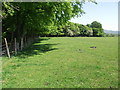
Path through a field
The all but invisible path runs through a sheep field alongside Hacking Wood.
Image: © philandju
Taken: 25 May 2012
0.21 miles
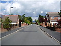
8
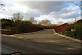
The entrance to The Old Zoo, Brockhall Village
At the end of this winding road there is a very interesting shaped house
Image: © Alexander P Kapp
Taken: 1 Mar 2006
0.21 miles