IMAGES TAKEN NEAR TO
Harwood Lane, BLACKBURN, BB6 7TB
Introduction
This page details the photographs taken nearby to Harwood Lane, BB6 7TB by members of the Geograph project.
The Geograph project started in 2005 with the aim of publishing, organising and preserving representative images for every square kilometre of Great Britain, Ireland and the Isle of Man.

There are currently over 7.5m images from over14,400 individuals and you can help contribute to the project by visiting https://www.geograph.org.uk
Image Map
Images are licensed for reuse under creativecommons.org/licenses/by-sa/2.0
Notes
- Clicking on the map will re-center to the selected point.
- The higher the marker number, the further away the image location is from the centre of the postcode.
Image Listing (27 Images Found)
Images are licensed for reuse under creativecommons.org/licenses/by-sa/2.0
Image
Details
Distance
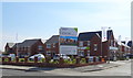
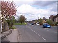
2

Bus stop and shelter on Harwood Lane, Great Harwood
Looking north east on the B6535.
Image: © JThomas
Taken: 19 Apr 2019
0.02 miles
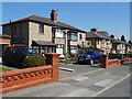
3
Lyndon Park
New housing development off Harwood Lane, Great Harwood.
Image: © JThomas
Taken: 19 Apr 2019
0.04 miles
4
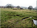
Path to Whalley Nab
The initial stages of the footpath as it leaves Great Harwood - a soggy nasty morass that will deter many walkers.
Image: © Chris Heaton
Taken: 2 Feb 2010
0.04 miles
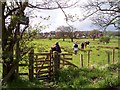
7
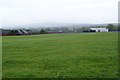
Lyndon Avenue playing fields
The old Great Harwood Town football ground was at the far end. In the far distance, and not very clear on this rainy day, is Great Hameldon.
Image: © Bill Boaden
Taken: 12 May 2013
0.08 miles
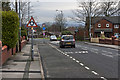
9
Mini-roundabout on Harwood Lane
The main route round the northern side of the town, which mostly passes through residential suburbs just like this.
Image: © Bill Boaden
Taken: 12 May 2013
0.09 miles
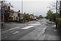
10

Rotary Club Purple Pinkie
Situated on the area know locally as the triangle, just opposite the junction of Lyndon Avenue and Harwood lane are the Purple Crocuses. These are some of the 40,000 planted across Great Harwood and Rishton by Rotarians with help from children and volunteers to celebrate the Rotarians success towards eradicating Polio from the worlds children.
Since 1983 Rotary Clubs worldwide have worked to reduce the number of children crippled or dying of Polio from 1000 per day to 2 per day in 2011, total eradication is now close.
All children vaccinated have their little fingers dyed purple hence the “Purple Pinkie” represented by these crocuses.
Image: © Steve Houldsworth
Taken: 23 Feb 2019
0.10 miles