IMAGES TAKEN NEAR TO
Balfour Street, BLACKBURN, BB6 7SZ
Introduction
This page details the photographs taken nearby to Balfour Street, BB6 7SZ by members of the Geograph project.
The Geograph project started in 2005 with the aim of publishing, organising and preserving representative images for every square kilometre of Great Britain, Ireland and the Isle of Man.

There are currently over 7.5m images from over14,400 individuals and you can help contribute to the project by visiting https://www.geograph.org.uk
Image Map (20 Images)

Leaflet Map data © OpenStreetMap
Images are licensed for reuse under creativecommons.org/licenses/by-sa/2.0
Notes
- Clicking on the map will re-center to the selected point.
- The higher the marker number, the further away the image location is from the centre of the postcode.
Image Listing (20 Images Found)
Images are licensed for reuse under creativecommons.org/licenses/by-sa/2.0
Image
Details
Distance
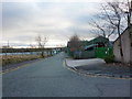
4
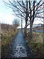
Footpath from Balfour Street to Lyndon Avenue
Image: © Alexander P Kapp
Taken: 11 Jan 2011
0.07 miles
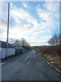
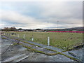
5
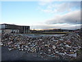
Part of what was Great Harwood Football Ground
Image: © Alexander P Kapp
Taken: 11 Jan 2011
0.08 miles
6
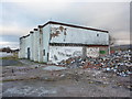
Part of what was Great Harwood Football Ground
Image: © Alexander P Kapp
Taken: 11 Jan 2011
0.08 miles
7
Turnstiles, Great Harwood Football Ground
Image: © Alexander P Kapp
Taken: 11 Jan 2011
0.09 miles
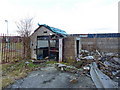
8
Part of what was Great Harwood Football Ground
Image: © Alexander P Kapp
Taken: 11 Jan 2011
0.10 miles
9
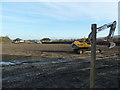
Former football ground
Being prepared for house building.
Image: © Alexander P Kapp
Taken: 17 Nov 2011
0.12 miles
10
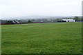
Lyndon Avenue playing fields
The old Great Harwood Town football ground was at the far end. In the far distance, and not very clear on this rainy day, is Great Hameldon.
Image: © Bill Boaden
Taken: 12 May 2013
0.15 miles