IMAGES TAKEN NEAR TO
Grange Avenue, BLACKBURN, BB6 7PB
Introduction
This page details the photographs taken nearby to Grange Avenue, BB6 7PB by members of the Geograph project.
The Geograph project started in 2005 with the aim of publishing, organising and preserving representative images for every square kilometre of Great Britain, Ireland and the Isle of Man.

There are currently over 7.5m images from over14,400 individuals and you can help contribute to the project by visiting https://www.geograph.org.uk
Image Map (Loading...)


Getting Data...Please wait
Leaflet Map data © OpenStreetMap
Images are licensed for reuse under creativecommons.org/licenses/by-sa/2.0
Notes
- Clicking on the map will re-center to the selected point.
- The higher the marker number, the further away the image location is from the centre of the postcode.
Image Listing (60 Images Found)
Images are licensed for reuse under creativecommons.org/licenses/by-sa/2.0
Image
Details
Distance
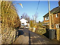
3
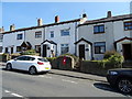
Houses on Cliffe Lane, Great Harwood
Showing position of Postbox No. BB6 84.
See Image] for postbox.
Image: © JThomas
Taken: 19 Apr 2019
0.07 miles
4
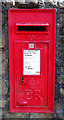
Elizabeth II postbox on Cliffe Lane, Great Harwood
Postbox No. BB6 84.
See Image] for context.
Image: © JThomas
Taken: 19 Apr 2019
0.08 miles
5
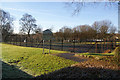
Lowerfold Park
A Hyndburn Council leisure facility.
Image: © Bill Boaden
Taken: 21 Jan 2011
0.09 miles
7
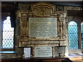
The Parish Church of St Bartholomew, Great Harwood, War Memorial
Image: © Alexander P Kapp
Taken: 4 Mar 2010
0.14 miles
8
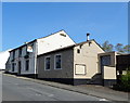
The Dog & Otter, Great Harwood
On Cliffe Lane.
Image: © JThomas
Taken: 19 Apr 2019
0.14 miles
9
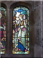
The Parish Church of St Bartholomew, Great Harwood, Stained glass window
Image: © Alexander P Kapp
Taken: 4 Mar 2010
0.14 miles
10
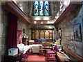
The Parish Church of St Bartholomew, Great Harwood, Interior
Image: © Alexander P Kapp
Taken: 4 Mar 2010
0.14 miles