IMAGES TAKEN NEAR TO
Moleside Close, ACCRINGTON, BB5 6QH
Introduction
This page details the photographs taken nearby to Moleside Close, BB5 6QH by members of the Geograph project.
The Geograph project started in 2005 with the aim of publishing, organising and preserving representative images for every square kilometre of Great Britain, Ireland and the Isle of Man.

There are currently over 7.5m images from over14,400 individuals and you can help contribute to the project by visiting https://www.geograph.org.uk
Image Map
Images are licensed for reuse under creativecommons.org/licenses/by-sa/2.0
Notes
- Clicking on the map will re-center to the selected point.
- The higher the marker number, the further away the image location is from the centre of the postcode.
Image Listing (48 Images Found)
Images are licensed for reuse under creativecommons.org/licenses/by-sa/2.0
Image
Details
Distance
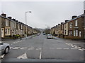
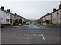
2
Back street between Bold Street and Stanley Street, Accrington
Image: © Alexander P Kapp
Taken: 12 Jan 2011
0.06 miles
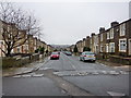
4
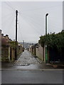
Back street between Stanley Street and Avenue Parade, Accrington
Image: © Alexander P Kapp
Taken: 12 Jan 2011
0.07 miles
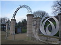
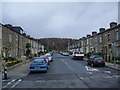
6
Looking out into Accrington
Dusk approaches on a winter afternoon. Avenue Parade is viewed through the recently renewed gateway of Peel Park.
Image: © John H Darch
Taken: 2 Dec 2012
0.07 miles

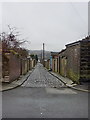
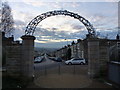
8
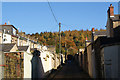
Back passage at the top of Accrington
Peel Park rises up behind, overlooking the town.
Image: © Bill Boaden
Taken: 10 Nov 2013
0.08 miles