IMAGES TAKEN NEAR TO
Walter Street, ACCRINGTON, BB5 6NE
Introduction
This page details the photographs taken nearby to Walter Street, BB5 6NE by members of the Geograph project.
The Geograph project started in 2005 with the aim of publishing, organising and preserving representative images for every square kilometre of Great Britain, Ireland and the Isle of Man.

There are currently over 7.5m images from over14,400 individuals and you can help contribute to the project by visiting https://www.geograph.org.uk
Image Map
Images are licensed for reuse under creativecommons.org/licenses/by-sa/2.0
Notes
- Clicking on the map will re-center to the selected point.
- The higher the marker number, the further away the image location is from the centre of the postcode.
Image Listing (66 Images Found)
Images are licensed for reuse under creativecommons.org/licenses/by-sa/2.0
Image
Details
Distance
2
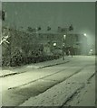
Snow falling on Edgar Street, Huncoat, at night
Image: © Paul Best
Taken: 25 Dec 2004
0.02 miles
3
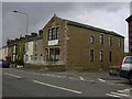
Accrington & Church Industrial Co-Operative Society Limited 1886, Station Road
Now converted into flats
Image: © Robert Wade
Taken: 2 Sep 2009
0.02 miles
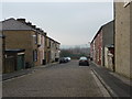
4

Blackburn to Burnley Railway
Looking northeast from Meadow Top Bridge
Image: © Alexander P Kapp
Taken: 3 Mar 2011
0.03 miles


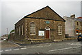

10

Former Co-op building on Station Road, Huncoat
Image: © Alexander P Kapp
Taken: 3 Mar 2011
0.06 miles