IMAGES TAKEN NEAR TO
Burnley Road, ACCRINGTON, BB5 6JZ
Introduction
This page details the photographs taken nearby to Burnley Road, BB5 6JZ by members of the Geograph project.
The Geograph project started in 2005 with the aim of publishing, organising and preserving representative images for every square kilometre of Great Britain, Ireland and the Isle of Man.

There are currently over 7.5m images from over14,400 individuals and you can help contribute to the project by visiting https://www.geograph.org.uk
Image Map
Images are licensed for reuse under creativecommons.org/licenses/by-sa/2.0
Notes
- Clicking on the map will re-center to the selected point.
- The higher the marker number, the further away the image location is from the centre of the postcode.
Image Listing (31 Images Found)
Images are licensed for reuse under creativecommons.org/licenses/by-sa/2.0
Image
Details
Distance
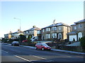
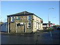
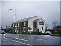
7
The Griffins Head, Huncoat
The Griffins Head public house at the corner of Higher Gate Road and Burnley Road.
Image: © David Dixon
Taken: 15 Apr 2012
0.12 miles
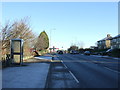
8
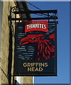
Sign for the Griffins Head public house, Huncoat
Image: © JThomas
Taken: 26 Nov 2016
0.12 miles
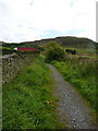
9
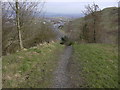
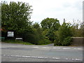
Footpath Peel Park
This leads to the A56 parking area
Image: © Robert Wade
Taken: 11 Mar 2009
0.13 miles
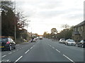
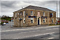
10
Griffins Head Inn, Burnley Road, Accrington
Image: © Alexander P Kapp
Taken: 13 Jan 2008
0.13 miles