IMAGES TAKEN NEAR TO
Hatfield Road, ACCRINGTON, BB5 6DF
Introduction
This page details the photographs taken nearby to Hatfield Road, BB5 6DF by members of the Geograph project.
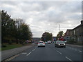
The Geograph project started in 2005 with the aim of publishing, organising and preserving representative images for every square kilometre of Great Britain, Ireland and the Isle of Man.

There are currently over 7.5m images from over14,400 individuals and you can help contribute to the project by visiting https://www.geograph.org.uk
Image Map
Images are licensed for reuse under creativecommons.org/licenses/by-sa/2.0
Notes
- Clicking on the map will re-center to the selected point.
- The higher the marker number, the further away the image location is from the centre of the postcode.
Image Listing (58 Images Found)
Images are licensed for reuse under creativecommons.org/licenses/by-sa/2.0
Image
Details
Distance
1
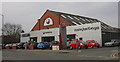
"Accrington Garages" The Motor House Burnley Road Accrington Lancashire
Image: © Robert Wade
Taken: 18 Mar 2010
0.05 miles
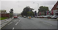
2
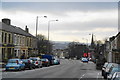
Burnley Road, Accrington
The spire of St John's is on the right.
Image: © Bill Boaden
Taken: 5 Jan 2013
0.06 miles
3
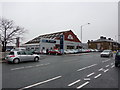
Accrington Garages, Burnley Road, Accrington
Image: © Alexander P Kapp
Taken: 12 Jan 2011
0.08 miles
4
Burnley Road, Accrington
Looking towards the town centre
Image: © Robert Wade
Taken: 2 Sep 2009
0.09 miles
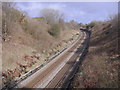
5
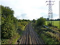
Railway southwest of Accrington Cemetery
Image: © Alexander P Kapp
Taken: 7 Sep 2010
0.10 miles
7
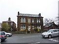
Nos 207 & 209 Burnley Road, Accrington
Image: © Alexander P Kapp
Taken: 12 Jan 2011
0.10 miles
8
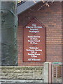
First Church of Christ Scientist, Accrington, Sign
Image: © Alexander P Kapp
Taken: 12 Jan 2011
0.10 miles
9
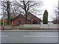
First Church of Christ Scientist, Accrington
Image: © Alexander P Kapp
Taken: 12 Jan 2011
0.10 miles