IMAGES TAKEN NEAR TO
Marlborough Road, ACCRINGTON, BB5 6AY
Introduction
This page details the photographs taken nearby to Marlborough Road, BB5 6AY by members of the Geograph project.
The Geograph project started in 2005 with the aim of publishing, organising and preserving representative images for every square kilometre of Great Britain, Ireland and the Isle of Man.

There are currently over 7.5m images from over14,400 individuals and you can help contribute to the project by visiting https://www.geograph.org.uk
Image Map
Images are licensed for reuse under creativecommons.org/licenses/by-sa/2.0
Notes
- Clicking on the map will re-center to the selected point.
- The higher the marker number, the further away the image location is from the centre of the postcode.
Image Listing (98 Images Found)
Images are licensed for reuse under creativecommons.org/licenses/by-sa/2.0
Image
Details
Distance
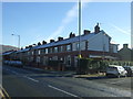
2
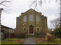
St. Joseph's RC Church, Belgarth Road, Accrington, BB5 6AH
Image: © Robert Wade
Taken: 18 Mar 2010
0.04 miles
4
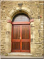
St Joseph's RC Church, Accrington, Doorway
Image: © Alexander P Kapp
Taken: 12 Jun 2009
0.05 miles
6
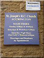
St Joseph's RC Church, Accrington, Sign
Image: © Alexander P Kapp
Taken: 12 Jun 2009
0.05 miles
7
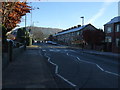
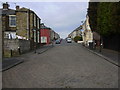
Zebra crossing on Queen's Road (B6237)
Looking east.
Image: © JThomas
Taken: 26 Nov 2016
0.07 miles
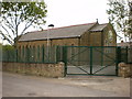
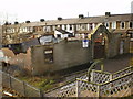
8
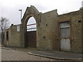
Derelict Building AD1903, Meadow Bank, Accrington
A chapel perhaps?
Image: © Robert Wade
Taken: 18 Mar 2010
0.07 miles
9
Demolition site at Meadow Top Crossing
Image: © Alexander P Kapp
Taken: 11 Feb 2009
0.07 miles
10
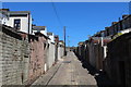
Alleyway leading North from Owen Street, Accrington
Running parallel with Haywood Road
Image: © Chris Heaton
Taken: 4 Jul 2018
0.07 miles