IMAGES TAKEN NEAR TO
Simmons Way, ACCRINGTON, BB5 5WW
Introduction
This page details the photographs taken nearby to Simmons Way, BB5 5WW by members of the Geograph project.
The Geograph project started in 2005 with the aim of publishing, organising and preserving representative images for every square kilometre of Great Britain, Ireland and the Isle of Man.

There are currently over 7.5m images from over14,400 individuals and you can help contribute to the project by visiting https://www.geograph.org.uk
Image Map
Images are licensed for reuse under creativecommons.org/licenses/by-sa/2.0
Notes
- Clicking on the map will re-center to the selected point.
- The higher the marker number, the further away the image location is from the centre of the postcode.
Image Listing (55 Images Found)
Images are licensed for reuse under creativecommons.org/licenses/by-sa/2.0
Image
Details
Distance
1
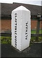
Old Boundary Marker by the A678, Burnley Road, Clayton-le-Moors
Parish Boundary Marker by the A678, in parish of Clayton-Le-Moors (Hyndburn District), Burnley Road, at roundabout junction with Bold Venture Way, on North side of road.
Inscription reads vertically:-
: CLAYTON-LE-MOORS : : ALTHAM. :
Surveyed
Milestone Society National ID: LA_BUBB07pb
Image: © Milestone Society
Taken: Unknown
0.08 miles
2
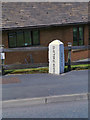
Boundary Marker
Marker stone at the side of Burnley Road (A678), marking the boundary between the Clayton-le-Moors and Altham districts.
Image: © David Dixon
Taken: 12 May 2012
0.08 miles
3
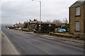
Footpath leaving Burnley Road
You might miss this if you weren't looking for it. The sign is by the bus stop in the centre.
Image: © Bill Boaden
Taken: 2 Mar 2013
0.09 miles
5
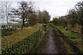
Footpath off Burnley Road
Following the route of a former track. There is a sign saying that this is maintained by local residents and it was certainly much tidier than most.
Image: © Bill Boaden
Taken: 2 Mar 2013
0.11 miles
6
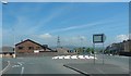
Leeds & Liverpool Canal, Clayton-le-Moors
Image: © Neil Theasby
Taken: 9 Nov 2014
0.12 miles
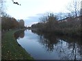
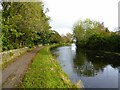
7
Leeds & Liverpool Canal, Clayton-le-Moors
The halfway point of the canal.
Image: © John H Darch
Taken: 13 Jul 2014
0.12 miles

9
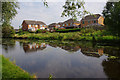
Leeds & Liverpool Canal, Clayton-le-Moors
The houses are on Pilkington Drive and Rosebank.
Image: © Ian Taylor
Taken: 27 Aug 2019
0.16 miles
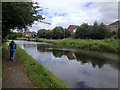
10
Leeds and Liverpool Canal
The towpath is approaching some green security fencing that comes down to the canal from the local school.
Image: © Kevin Waterhouse
Taken: 23 Oct 2023
0.16 miles