IMAGES TAKEN NEAR TO
Trout Beck, ACCRINGTON, BB5 5TN
Introduction
This page details the photographs taken nearby to Trout Beck, BB5 5TN by members of the Geograph project.
The Geograph project started in 2005 with the aim of publishing, organising and preserving representative images for every square kilometre of Great Britain, Ireland and the Isle of Man.

There are currently over 7.5m images from over14,400 individuals and you can help contribute to the project by visiting https://www.geograph.org.uk
Image Map
Images are licensed for reuse under creativecommons.org/licenses/by-sa/2.0
Notes
- Clicking on the map will re-center to the selected point.
- The higher the marker number, the further away the image location is from the centre of the postcode.
Image Listing (19 Images Found)
Images are licensed for reuse under creativecommons.org/licenses/by-sa/2.0
Image
Details
Distance
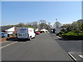
2
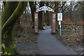
The entrance to The Woodlands, Clayton-le-Moors
Image: © Ian Greig
Taken: 19 Feb 2016
0.10 miles
3
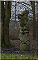
A wood carving at The Woodlands, Clayton-le-Moors
I don’t know what it is, but it’s unlikely to be Snoopy the dog
Image: © Ian Greig
Taken: 19 Feb 2016
0.11 miles
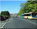
5
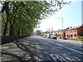
Whalley Road, Clayton-le-Moors
Looking south west on the A680.
Image: © JThomas
Taken: 19 Apr 2019
0.14 miles
6
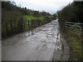
Access Lane to Recycling Operation
Muddy access track leading from the A680 Accrington Road to a recycling operation, beside Hyndburn Brook.
Image: © Chris Heaton
Taken: 2 Feb 2010
0.19 miles
7
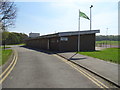
Changing rooms, Wilson Playing Fields, Clayton-le-Moors
Image: © JThomas
Taken: 19 Apr 2019
0.20 miles
9
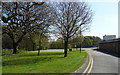
Sycamore Crescent, Clayton-le-Moors
Looking east.
Image: © JThomas
Taken: 19 Apr 2019
0.22 miles
10

Bridge over Harwood Brook
The bridge where Hayes lane crosses over Harwood Brook where Harwood Brook joins the river Hyndburn.
Image: © Steve Houldsworth
Taken: 16 Nov 2013
0.23 miles