IMAGES TAKEN NEAR TO
Talbot Avenue, ACCRINGTON, BB5 5NJ
Introduction
This page details the photographs taken nearby to Talbot Avenue, BB5 5NJ by members of the Geograph project.
The Geograph project started in 2005 with the aim of publishing, organising and preserving representative images for every square kilometre of Great Britain, Ireland and the Isle of Man.

There are currently over 7.5m images from over14,400 individuals and you can help contribute to the project by visiting https://www.geograph.org.uk
Image Map
Images are licensed for reuse under creativecommons.org/licenses/by-sa/2.0
Notes
- Clicking on the map will re-center to the selected point.
- The higher the marker number, the further away the image location is from the centre of the postcode.
Image Listing (108 Images Found)
Images are licensed for reuse under creativecommons.org/licenses/by-sa/2.0
Image
Details
Distance
1
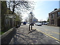
Bus stop and shelter on Whalley Road, Clayton-le-Moors
Looking south on the A680.
Image: © JThomas
Taken: 19 Apr 2019
0.06 miles
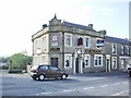
3
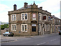
The Volunteer
Whalley Road, Clayton-Le-Moors.
Image: © David Dixon
Taken: 19 Jun 2010
0.07 miles
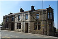
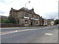
7
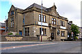
Clayton-Le-Moors Conservative Club
Whalley Road.
Image: © David Dixon
Taken: 19 Jun 2010
0.07 miles
8
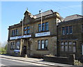
Clayton-le-Moors Conservative Club
On Whalley Road.
Image: © JThomas
Taken: 19 Apr 2019
0.07 miles
9
Clayton-Le-Moors Conservative Club
Adjacent to the Leeds and Liverpool canal.
Image: © Richard Hoare
Taken: 16 Aug 2015
0.08 miles
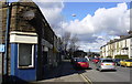
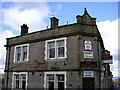
10
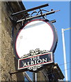
Faded sign for the Albion public house, Clayton-le-Moors
See Image] for context.
Image: © JThomas
Taken: 19 Apr 2019
0.08 miles