IMAGES TAKEN NEAR TO
Atlas Street, ACCRINGTON, BB5 5LT
Introduction
This page details the photographs taken nearby to Atlas Street, BB5 5LT by members of the Geograph project.
The Geograph project started in 2005 with the aim of publishing, organising and preserving representative images for every square kilometre of Great Britain, Ireland and the Isle of Man.

There are currently over 7.5m images from over14,400 individuals and you can help contribute to the project by visiting https://www.geograph.org.uk
Image Map
Images are licensed for reuse under creativecommons.org/licenses/by-sa/2.0
Notes
- Clicking on the map will re-center to the selected point.
- The higher the marker number, the further away the image location is from the centre of the postcode.
Image Listing (59 Images Found)
Images are licensed for reuse under creativecommons.org/licenses/by-sa/2.0
Image
Details
Distance
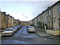
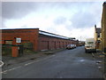
1

Track along the east side of Atlas Mill
Image: © Alexander P Kapp
Taken: 20 Nov 2009
0.03 miles

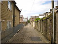
4
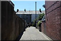
Alleyway off Whinfield Street, Enfield
Behind terraced housing parallel with Whalley Road, Enfield in the northern environs of Accrington
Image: © Chris Heaton
Taken: 4 Jul 2018
0.05 miles
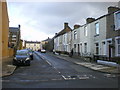
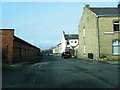
6
Terraced Housing on Whalley Road
The A680 on the northern fringes of Accrington, as seen from Adelaide Street
Image: © Chris Heaton
Taken: 4 Jul 2018
0.07 miles
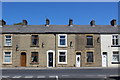
7

Whalley Road near The Greyhound, Accrington
Image: © Alexander P Kapp
Taken: 8 Feb 2008
0.07 miles
10
Back street between Whalley Road and Waterloo Street
Image: © Alexander P Kapp
Taken: 12 Jun 2009
0.09 miles