IMAGES TAKEN NEAR TO
Packington Brook, ACCRINGTON, BB5 4EX
Introduction
This page details the photographs taken nearby to Packington Brook, BB5 4EX by members of the Geograph project.
The Geograph project started in 2005 with the aim of publishing, organising and preserving representative images for every square kilometre of Great Britain, Ireland and the Isle of Man.

There are currently over 7.5m images from over14,400 individuals and you can help contribute to the project by visiting https://www.geograph.org.uk
Image Map
Images are licensed for reuse under creativecommons.org/licenses/by-sa/2.0
Notes
- Clicking on the map will re-center to the selected point.
- The higher the marker number, the further away the image location is from the centre of the postcode.
Image Listing (53 Images Found)
Images are licensed for reuse under creativecommons.org/licenses/by-sa/2.0
Image
Details
Distance
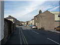
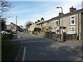
2
Garages off White Ash Lane, Oswaldtwistle
Image: © Alexander P Kapp
Taken: 14 Mar 2011
0.11 miles
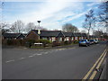
4
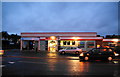
Spar convenience store on Thwaites Road
Image: © Bill Boaden
Taken: 15 Jan 2011
0.14 miles
5
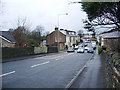
Smithy Bridge
Carries the B6234 over Lottice Brook
Image: © Alexander P Kapp
Taken: 7 Jan 2008
0.14 miles
7
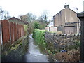
Lottice Brook
As it flows under Smithy Bridge
Image: © Alexander P Kapp
Taken: 7 Jan 2008
0.15 miles
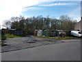
8
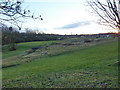
Site of Whiteash Paper Mill
Now part of an open space
Image: © Alexander P Kapp
Taken: 11 Jan 2011
0.18 miles
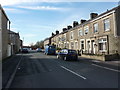
9
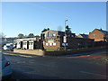
Tricky's public house, Oswaldtwistle
On Banbury Avenue.
Image: © JThomas
Taken: 26 Nov 2016
0.19 miles