IMAGES TAKEN NEAR TO
Manor Place, ACCRINGTON, BB5 4DX
Introduction
This page details the photographs taken nearby to Manor Place, BB5 4DX by members of the Geograph project.
The Geograph project started in 2005 with the aim of publishing, organising and preserving representative images for every square kilometre of Great Britain, Ireland and the Isle of Man.

There are currently over 7.5m images from over14,400 individuals and you can help contribute to the project by visiting https://www.geograph.org.uk
Image Map
Images are licensed for reuse under creativecommons.org/licenses/by-sa/2.0
Notes
- Clicking on the map will re-center to the selected point.
- The higher the marker number, the further away the image location is from the centre of the postcode.
Image Listing (31 Images Found)
Images are licensed for reuse under creativecommons.org/licenses/by-sa/2.0
Image
Details
Distance
2
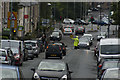
A lollipop man at work in Peel Bank
It looks hazardous!
Image: © Ian Greig
Taken: 9 Sep 2016
0.02 miles
3
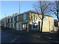
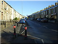
Small superstore on Dill Hill Lane (B6231), Church
Image: © JThomas
Taken: 26 Nov 2016
0.04 miles
4
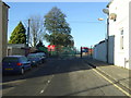
Road towards St Nicholas Church of England Primary School
Image: © JThomas
Taken: 26 Nov 2016
0.05 miles
5
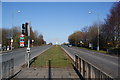
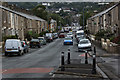
Dunkenhalgh Way, Accrington
The A6185, also known as Hyndburn Road, which is the main link between Accrington and the M65.
Image: © Bill Boaden
Taken: 2 Mar 2013
0.05 miles
6

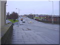
Dill Hall Lane, Accrington
A useful road around the north side of Accrington.
Image: © Bill Boaden
Taken: 2 Mar 2013
0.05 miles
7
Dill Hill Lane (B6231), Church
Looking north east.
Image: © JThomas
Taken: 26 Nov 2016
0.08 miles
10

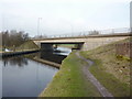
Leeds and Liverpool Canal, Towpath
As it approaches the bridge over Peel Arm
Image: © Alexander P Kapp
Taken: 18 Feb 2011
0.15 miles