IMAGES TAKEN NEAR TO
Queens Road West, ACCRINGTON, BB5 4BA
Introduction
This page details the photographs taken nearby to Queens Road West, BB5 4BA by members of the Geograph project.
The Geograph project started in 2005 with the aim of publishing, organising and preserving representative images for every square kilometre of Great Britain, Ireland and the Isle of Man.

There are currently over 7.5m images from over14,400 individuals and you can help contribute to the project by visiting https://www.geograph.org.uk
Image Map
Images are licensed for reuse under creativecommons.org/licenses/by-sa/2.0
Notes
- Clicking on the map will re-center to the selected point.
- The higher the marker number, the further away the image location is from the centre of the postcode.
Image Listing (33 Images Found)
Images are licensed for reuse under creativecommons.org/licenses/by-sa/2.0
Image
Details
Distance
2
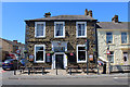
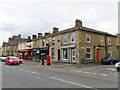
The Grey Horse, Accrington
Public house on the A680, Whalley Road.
Image: © Chris Heaton
Taken: 4 Jul 2018
0.10 miles
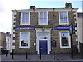
4
Grey Horse, 263 Whalley Road, Accrington
Image: © Alexander P Kapp
Taken: 8 Feb 2008
0.10 miles
5
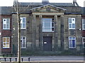
Moorhead High School
Looking at the entrance it would seem that it is never used now, with a security fence across and grass and weeds growing through the fence.
Image: © Alexander P Kapp
Taken: 7 Nov 2008
0.10 miles
6
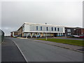
New extension to Accrington Academy
Image: © Alexander P Kapp
Taken: 18 Feb 2011
0.11 miles
10
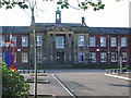
Accrington Academy
Representing part of the latest movement in education. This is the 6th Form building.
Image: © Bill Boaden
Taken: 2 Mar 2013
0.12 miles