IMAGES TAKEN NEAR TO
Green Haworth View, ACCRINGTON, BB5 3TH
Introduction
This page details the photographs taken nearby to Green Haworth View, BB5 3TH by members of the Geograph project.
The Geograph project started in 2005 with the aim of publishing, organising and preserving representative images for every square kilometre of Great Britain, Ireland and the Isle of Man.

There are currently over 7.5m images from over14,400 individuals and you can help contribute to the project by visiting https://www.geograph.org.uk
Image Map
Images are licensed for reuse under creativecommons.org/licenses/by-sa/2.0
Notes
- Clicking on the map will re-center to the selected point.
- The higher the marker number, the further away the image location is from the centre of the postcode.
Image Listing (20 Images Found)
Images are licensed for reuse under creativecommons.org/licenses/by-sa/2.0
Image
Details
Distance
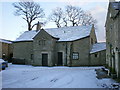
1
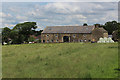
Rough Heys
Former 18th Century farmhouse and barn, now converted into private housing.
Grade II Listed Building.
Image: © Chris Heaton
Taken: 9 Jun 2019
0.13 miles
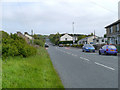
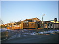
6
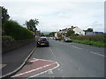
Broadfield towards Oswaldtwistle
Looking north west down the hill.
Image: © JThomas
Taken: 10 Sep 2018
0.21 miles
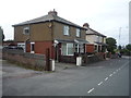
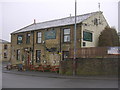
8
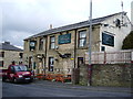
The Plough, Fielding Lane Oswaldtwistle
Image: © Alexander P Kapp
Taken: 14 Feb 2008
0.22 miles