IMAGES TAKEN NEAR TO
Red Shell Lane, ACCRINGTON, BB5 3RW
Introduction
This page details the photographs taken nearby to Red Shell Lane, BB5 3RW by members of the Geograph project.
The Geograph project started in 2005 with the aim of publishing, organising and preserving representative images for every square kilometre of Great Britain, Ireland and the Isle of Man.

There are currently over 7.5m images from over14,400 individuals and you can help contribute to the project by visiting https://www.geograph.org.uk
Image Map
Images are licensed for reuse under creativecommons.org/licenses/by-sa/2.0
Notes
- Clicking on the map will re-center to the selected point.
- The higher the marker number, the further away the image location is from the centre of the postcode.
Image Listing (11 Images Found)
Images are licensed for reuse under creativecommons.org/licenses/by-sa/2.0
Image
Details
Distance
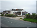
1

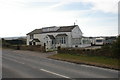
Red Shell Farm
Passing through the farmyard on Red Shell Lane
Image: © Chris Heaton
Taken: 23 Dec 2019
0.02 miles
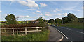
2

Red Shell Lane
Seen here running northwards to Red Shell Farm. The bridleway was the consistency of sloppy porridge upon my visit, churned up by several horses resident in the field.
Any worse, and the route would be unwalkable.
Image: © Chris Heaton
Taken: 23 Dec 2019
0.16 miles
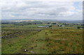
4
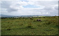
Ponies grazing near Red Shell Farm
The hill beyond is Great Hameldon, with Pendle to the left.
Image: © Bill Boaden
Taken: 3 Jul 2010
0.19 miles
5
Red Shell Lane
I liked the sign "Only foals and horses"
Image: © Ian Greig
Taken: 22 Sep 2016
0.20 miles
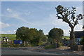
8
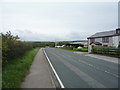
Haslingden Road
Looking south east on the B6236.
Image: © JThomas
Taken: 10 Sep 2018
0.22 miles
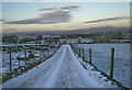
10
Red Shell Lane
It is now more like a former lane. Red Shell Farm is at the bottom of the slope.
Image: © Bill Boaden
Taken: 3 Jul 2010
0.25 miles