IMAGES TAKEN NEAR TO
Mill Hill, ACCRINGTON, BB5 3LX
Introduction
This page details the photographs taken nearby to Mill Hill, BB5 3LX by members of the Geograph project.
The Geograph project started in 2005 with the aim of publishing, organising and preserving representative images for every square kilometre of Great Britain, Ireland and the Isle of Man.

There are currently over 7.5m images from over14,400 individuals and you can help contribute to the project by visiting https://www.geograph.org.uk
Image Map
Images are licensed for reuse under creativecommons.org/licenses/by-sa/2.0
Notes
- Clicking on the map will re-center to the selected point.
- The higher the marker number, the further away the image location is from the centre of the postcode.
Image Listing (160 Images Found)
Images are licensed for reuse under creativecommons.org/licenses/by-sa/2.0
Image
Details
Distance
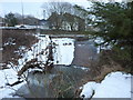
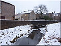
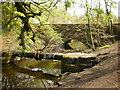
3
Tinker Brook
The bridge carries Mill Hill over the brook
Image: © Alexander P Kapp
Taken: 24 Mar 2009
0.03 miles
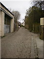
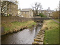
8
Straits
Looking down Straits from Union Road
Image: © Alexander P Kapp
Taken: 24 Mar 2009
0.04 miles
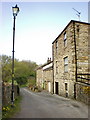
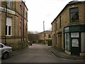
9
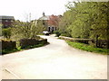
Mill Hill
With Spring Terrace in the distance
Image: © Alexander P Kapp
Taken: 20 Apr 2009
0.04 miles
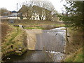
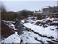
10
Bridge and pipe over Tinker Brook
Image: © Alexander P Kapp
Taken: 20 Apr 2009
0.04 miles