IMAGES TAKEN NEAR TO
Hippings Vale, ACCRINGTON, BB5 3LH
Introduction
This page details the photographs taken nearby to Hippings Vale, BB5 3LH by members of the Geograph project.
The Geograph project started in 2005 with the aim of publishing, organising and preserving representative images for every square kilometre of Great Britain, Ireland and the Isle of Man.

There are currently over 7.5m images from over14,400 individuals and you can help contribute to the project by visiting https://www.geograph.org.uk
Image Map
Images are licensed for reuse under creativecommons.org/licenses/by-sa/2.0
Notes
- Clicking on the map will re-center to the selected point.
- The higher the marker number, the further away the image location is from the centre of the postcode.
Image Listing (159 Images Found)
Images are licensed for reuse under creativecommons.org/licenses/by-sa/2.0
Image
Details
Distance
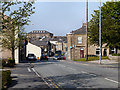
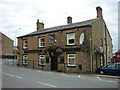
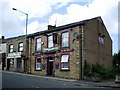
4
Tinker and Budget
Public house on Union Road.
Image: © David Dixon
Taken: 23 May 2012
0.08 miles
5
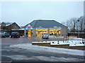
Tesco Express
It was built on the site of the old fire station
Image: © Alexander P Kapp
Taken: 12 Jan 2010
0.08 miles
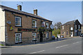
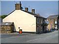
7
The Bay Horse, 226 Union Road, Oswaldtwistle
Image: © Alexander P Kapp
Taken: 11 Sep 2007
0.08 miles
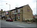
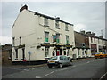
8
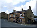
Tinker & Budget, 218 Union Road, Oswaldtwistle
Image: © Alexander P Kapp
Taken: 11 Sep 2007
0.09 miles