IMAGES TAKEN NEAR TO
Mount Pleasant Street, ACCRINGTON, BB5 3EN
Introduction
This page details the photographs taken nearby to Mount Pleasant Street, BB5 3EN by members of the Geograph project.
The Geograph project started in 2005 with the aim of publishing, organising and preserving representative images for every square kilometre of Great Britain, Ireland and the Isle of Man.

There are currently over 7.5m images from over14,400 individuals and you can help contribute to the project by visiting https://www.geograph.org.uk
Image Map
Images are licensed for reuse under creativecommons.org/licenses/by-sa/2.0
Notes
- Clicking on the map will re-center to the selected point.
- The higher the marker number, the further away the image location is from the centre of the postcode.
Image Listing (176 Images Found)
Images are licensed for reuse under creativecommons.org/licenses/by-sa/2.0
Image
Details
Distance
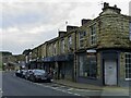
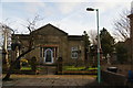
2
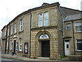
Former bank on Union Street, Oswaldtwistle
Image: © Alexander P Kapp
Taken: 12 Jan 2010
0.03 miles
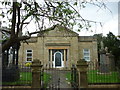
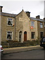
4
Rhyddings Methodist Church
At the end of Chapel Street. The inscription says it dates from 1984. This is the date of rebuilding of the church, but it retains the facade from the earlier building erected in 1845.
Image: © Bill Boaden
Taken: 5 Jan 2013
0.04 miles
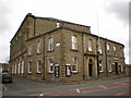
8
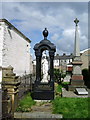
Rhyddings Methodist Church, Oswaldtwistle, Grave
Image: © Alexander P Kapp
Taken: 11 Sep 2007
0.04 miles