IMAGES TAKEN NEAR TO
Southwood Drive, ACCRINGTON, BB5 2TU
Introduction
This page details the photographs taken nearby to Southwood Drive, BB5 2TU by members of the Geograph project.
The Geograph project started in 2005 with the aim of publishing, organising and preserving representative images for every square kilometre of Great Britain, Ireland and the Isle of Man.

There are currently over 7.5m images from over14,400 individuals and you can help contribute to the project by visiting https://www.geograph.org.uk
Image Map
Images are licensed for reuse under creativecommons.org/licenses/by-sa/2.0
Notes
- Clicking on the map will re-center to the selected point.
- The higher the marker number, the further away the image location is from the centre of the postcode.
Image Listing (10 Images Found)
Images are licensed for reuse under creativecommons.org/licenses/by-sa/2.0
Image
Details
Distance
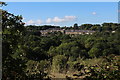
1
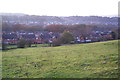
Evening view of Baxenden
Looking down from the fields of Laund Farm.
Image: © Bill Boaden
Taken: 6 Nov 2011
0.01 miles
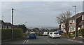
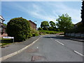
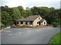
4
New houses at the end of Southworth Drive, Baxenden
Image: © Alexander P Kapp
Taken: 4 May 2011
0.10 miles
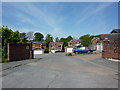
6
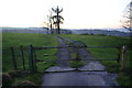
Gate to Old Bill's Laund Farm
This track provides access to Baxenden from farms higher up behind.
Image: © Bill Boaden
Taken: 6 Nov 2011
0.12 miles
7
View towards Baxenden
Looking over the wooded valley of Laund Clough
Image: © Chris Heaton
Taken: 5 Sep 2018
0.13 miles
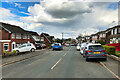
10

"Victoria" Manchester Road, Accrington
Image: © Alexander P Kapp
Taken: 14 Aug 2007
0.23 miles