IMAGES TAKEN NEAR TO
Hollins Lane, ACCRINGTON, BB5 2QY
Introduction
This page details the photographs taken nearby to Hollins Lane, BB5 2QY by members of the Geograph project.
The Geograph project started in 2005 with the aim of publishing, organising and preserving representative images for every square kilometre of Great Britain, Ireland and the Isle of Man.

There are currently over 7.5m images from over14,400 individuals and you can help contribute to the project by visiting https://www.geograph.org.uk
Image Map
Images are licensed for reuse under creativecommons.org/licenses/by-sa/2.0
Notes
- Clicking on the map will re-center to the selected point.
- The higher the marker number, the further away the image location is from the centre of the postcode.
Image Listing (53 Images Found)
Images are licensed for reuse under creativecommons.org/licenses/by-sa/2.0
Image
Details
Distance
1
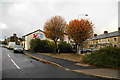
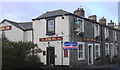
The Alma Inn, Baxenden
Named after the battle in the Crimean War. It is a bit obscured by trees from this angle near the junction of Hollins Lane with Manchester Road.
Image: © Bill Boaden
Taken: 29 Sep 2010
0.04 miles
2
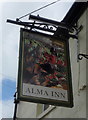
"Alma Inn" Manchester Road, Accrington
Image: © Alexander P Kapp
Taken: 14 Aug 2007
0.05 miles
5
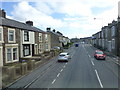
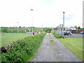
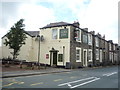
Manchester Road,Baxenden
Pocklington street can be seen on the left
Image: © Raymond Knapman
Taken: 7 Mar 2014
0.07 miles
7
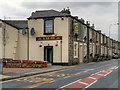
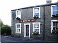
Manchester Road, The Alma Inn
A public house at the end of a row of private houses.
Image: © David Dixon
Taken: 20 May 2012
0.07 miles
8
The Alma Inn, Baxenden
On Manchester Road (A680).
Image: © JThomas
Taken: 17 Sep 2018
0.08 miles