IMAGES TAKEN NEAR TO
Whitecroft View, ACCRINGTON, BB5 2QP
Introduction
This page details the photographs taken nearby to Whitecroft View, BB5 2QP by members of the Geograph project.
The Geograph project started in 2005 with the aim of publishing, organising and preserving representative images for every square kilometre of Great Britain, Ireland and the Isle of Man.

There are currently over 7.5m images from over14,400 individuals and you can help contribute to the project by visiting https://www.geograph.org.uk
Image Map
Images are licensed for reuse under creativecommons.org/licenses/by-sa/2.0
Notes
- Clicking on the map will re-center to the selected point.
- The higher the marker number, the further away the image location is from the centre of the postcode.
Image Listing (55 Images Found)
Images are licensed for reuse under creativecommons.org/licenses/by-sa/2.0
Image
Details
Distance
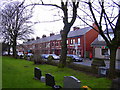
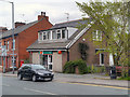
2
Ley St Allotments
Behind the terraced houses on the busy Manchester Rd (A680) there are these well tended allotments.
Image: © Mr T
Taken: 2 Jun 2006
0.06 miles
3
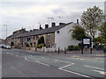
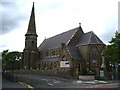
Manchester Road from St John's Church, Baxenden
Image: © Robert Wade
Taken: 30 Nov 2009
0.06 miles
4
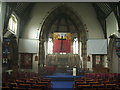
Interior of St John's Church, Baxenden
Image: © Alexander P Kapp
Taken: 11 May 2007
0.07 miles
5

Interior of St John's Church, Baxenden
Image: © Alexander P Kapp
Taken: 11 May 2007
0.08 miles
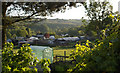
7
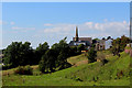
View towards St. John's Church, Baxenden
Taken from below the A680, Manchester Road - this looks north westwards towards the centre of Baxenden.
Image: © Chris Heaton
Taken: 5 Sep 2018
0.09 miles
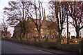
10
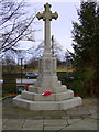
War Memorial, St John's Church, Baxenden
Image: © Robert Wade
Taken: 30 Nov 2009
0.10 miles