IMAGES TAKEN NEAR TO
Burns Drive, ACCRINGTON, BB5 2PY
Introduction
This page details the photographs taken nearby to Burns Drive, BB5 2PY by members of the Geograph project.
The Geograph project started in 2005 with the aim of publishing, organising and preserving representative images for every square kilometre of Great Britain, Ireland and the Isle of Man.

There are currently over 7.5m images from over14,400 individuals and you can help contribute to the project by visiting https://www.geograph.org.uk
Image Map
Images are licensed for reuse under creativecommons.org/licenses/by-sa/2.0
Notes
- Clicking on the map will re-center to the selected point.
- The higher the marker number, the further away the image location is from the centre of the postcode.
Image Listing (50 Images Found)
Images are licensed for reuse under creativecommons.org/licenses/by-sa/2.0
Image
Details
Distance
2
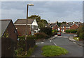
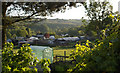
Southwood Drive, Baxenden
The main road giving access to a large area of new housing.
Image: © Bill Boaden
Taken: 6 Nov 2011
0.05 miles
4
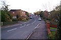
Manchester Road from St John's Church, Baxenden
Image: © Robert Wade
Taken: 30 Nov 2009
0.09 miles
5
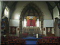
Interior of St John's Church, Baxenden
Image: © Alexander P Kapp
Taken: 11 May 2007
0.14 miles
7
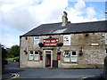
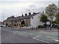
"Dog and Partridge, Back Lane, Accrington
Image: © Alexander P Kapp
Taken: 14 Aug 2007
0.14 miles
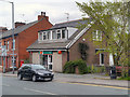
8
House on Hill Street, Baxenden
Showing position of Postbox No. BB5 260.
See Image] for postbox.
Image: © JThomas
Taken: 17 Sep 2018
0.14 miles
9
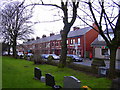
Ley St Allotments
Behind the terraced houses on the busy Manchester Rd (A680) there are these well tended allotments.
Image: © Mr T
Taken: 2 Jun 2006
0.14 miles
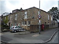
10
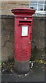
Elizabeth II postbox on Hollins Lane, Baxenden
Postbox No. BB5 260.
See Image] for context.
Image: © JThomas
Taken: 17 Sep 2018
0.15 miles