IMAGES TAKEN NEAR TO
Manchester Road, ACCRINGTON, BB5 2PD
Introduction
This page details the photographs taken nearby to Manchester Road, BB5 2PD by members of the Geograph project.
The Geograph project started in 2005 with the aim of publishing, organising and preserving representative images for every square kilometre of Great Britain, Ireland and the Isle of Man.

There are currently over 7.5m images from over14,400 individuals and you can help contribute to the project by visiting https://www.geograph.org.uk
Image Map
Images are licensed for reuse under creativecommons.org/licenses/by-sa/2.0
Notes
- Clicking on the map will re-center to the selected point.
- The higher the marker number, the further away the image location is from the centre of the postcode.
Image Listing (80 Images Found)
Images are licensed for reuse under creativecommons.org/licenses/by-sa/2.0
Image
Details
Distance
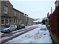
2
Granville Road, Accrington, Building
Image: © Alexander P Kapp
Taken: 11 Jan 2010
0.02 miles
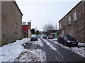
4
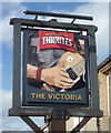
Sign for the Victoria public house, Acrrington
Image: © JThomas
Taken: 17 Sep 2018
0.04 miles
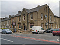
5
The Victoria public house, Acrrington
On Manchester Road.
Image: © JThomas
Taken: 17 Sep 2018
0.04 miles
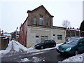
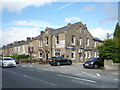
6
The Victoria
Public house on the corner of Henry Street and Manchester Road (A680)
Image: © David Dixon
Taken: 20 May 2012
0.04 miles
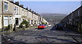
7
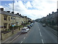
Manchester Road, Accrington
The Victoria pub can be seen on the left
Image: © Raymond Knapman
Taken: 7 Mar 2014
0.04 miles
8
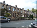
Terraced housing on Manchester Road Accrington
Image: © JThomas
Taken: 17 Sep 2018
0.04 miles
9
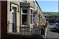
Terraced Housing on Harcourt Road, Accrington
Image: © Chris Heaton
Taken: 5 Sep 2018
0.04 miles