IMAGES TAKEN NEAR TO
Rough Lee Road, ACCRINGTON, BB5 2LN
Introduction
This page details the photographs taken nearby to Rough Lee Road, BB5 2LN by members of the Geograph project.
The Geograph project started in 2005 with the aim of publishing, organising and preserving representative images for every square kilometre of Great Britain, Ireland and the Isle of Man.

There are currently over 7.5m images from over14,400 individuals and you can help contribute to the project by visiting https://www.geograph.org.uk
Image Map
Images are licensed for reuse under creativecommons.org/licenses/by-sa/2.0
Notes
- Clicking on the map will re-center to the selected point.
- The higher the marker number, the further away the image location is from the centre of the postcode.
Image Listing (131 Images Found)
Images are licensed for reuse under creativecommons.org/licenses/by-sa/2.0
Image
Details
Distance
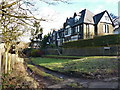
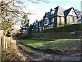
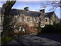
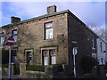
3
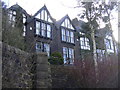
Eaton Bank
These lovely houses are tucked away but well worth a look.
Image: © Robert Wade
Taken: 10 Feb 2009
0.04 miles
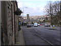
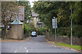
5
Road junction
Of Royds Street and Hollins Lane
Image: © Alexander P Kapp
Taken: 12 Feb 2010
0.06 miles
6
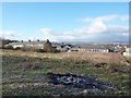
Vacant land near Yorkshire Street, Accrington
Image: © Alexander P Kapp
Taken: 12 Feb 2010
0.06 miles
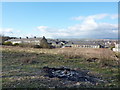
9
Hollins Lane
Despite the road going to the left, both these roads are Hollins Lane.
Image: © Stuart Wilding
Taken: 17 Sep 2014
0.08 miles
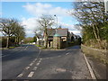
10
Lemonious Street junction Rough Lee Road
I don't think I have ever seen this street name before, have you?
Image: © Robert Wade
Taken: 10 Feb 2009
0.09 miles