IMAGES TAKEN NEAR TO
Royds Street, ACCRINGTON, BB5 2JH
Introduction
This page details the photographs taken nearby to Royds Street, BB5 2JH by members of the Geograph project.
The Geograph project started in 2005 with the aim of publishing, organising and preserving representative images for every square kilometre of Great Britain, Ireland and the Isle of Man.

There are currently over 7.5m images from over14,400 individuals and you can help contribute to the project by visiting https://www.geograph.org.uk
Image Map
Images are licensed for reuse under creativecommons.org/licenses/by-sa/2.0
Notes
- Clicking on the map will re-center to the selected point.
- The higher the marker number, the further away the image location is from the centre of the postcode.
Image Listing (205 Images Found)
Images are licensed for reuse under creativecommons.org/licenses/by-sa/2.0
Image
Details
Distance
1
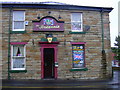
Britannia Inn, 36 Nuttall Street, Accrington, Lancashire, BB5 2HN
Image: © Robert Wade
Taken: 2 Oct 2009
0.05 miles

4
Tom Hodgson's Toffee Works, Cotton Street
Image: © Alexander P Kapp
Taken: 18 Nov 2009
0.09 miles
5
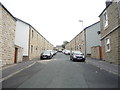
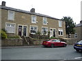
Augusta Street, Accrington
Looking south east.
Image: © JThomas
Taken: 10 Sep 2018
0.09 miles
6

The Poplar Social Club, Accrington
On Wellington Street.
Image: © JThomas
Taken: 10 Sep 2018
0.11 miles
7
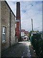
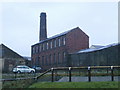
Back street off Cotton Street, Accrington
Leading to what was Wellington Saw Mills (1800s). The chimney is part of what was Tom Hodgson's toffee works
Image: © Alexander P Kapp
Taken: 2 Apr 2008
0.11 miles
8
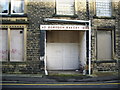
Doorway
Doorway to what was Borough Bakery on Jacob Street
Image: © Alexander P Kapp
Taken: 1 Nov 2007
0.11 miles

10

Building and joinery contractors, Accrington
Image: © JThomas
Taken: 10 Sep 2018
0.11 miles