IMAGES TAKEN NEAR TO
South Street, ACCRINGTON, BB5 2HP
Introduction
This page details the photographs taken nearby to South Street, BB5 2HP by members of the Geograph project.
The Geograph project started in 2005 with the aim of publishing, organising and preserving representative images for every square kilometre of Great Britain, Ireland and the Isle of Man.

There are currently over 7.5m images from over14,400 individuals and you can help contribute to the project by visiting https://www.geograph.org.uk
Image Map
Images are licensed for reuse under creativecommons.org/licenses/by-sa/2.0
Notes
- Clicking on the map will re-center to the selected point.
- The higher the marker number, the further away the image location is from the centre of the postcode.
Image Listing (162 Images Found)
Images are licensed for reuse under creativecommons.org/licenses/by-sa/2.0
Image
Details
Distance
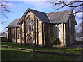
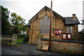
2
Christ Church Hall, Accrington
It has been converted in to housing
Image: © Alexander P Kapp
Taken: 14 Feb 2008
0.05 miles
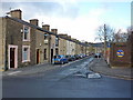
4
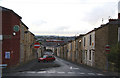
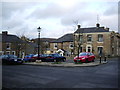
Royds Street, Accrington
Offering views of the town centre.
Image: © Bill Boaden
Taken: 29 Sep 2010
0.06 miles
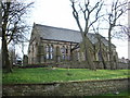
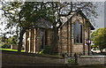
7
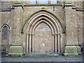
Christ Church, Accrington, Doorway
Image: © Alexander P Kapp
Taken: 14 Feb 2008
0.06 miles
8
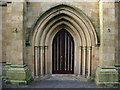
Christ Church, Accrington, Doorway
Image: © Alexander P Kapp
Taken: 14 Feb 2008
0.06 miles
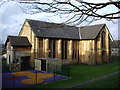
9
Trinity Community Church
Formerly Christ Church, Accrington.
Image: © Bill Boaden
Taken: 29 Sep 2010
0.06 miles