IMAGES TAKEN NEAR TO
Goodshaw Lane, ACCRINGTON, BB5 2DW
Introduction
This page details the photographs taken nearby to Goodshaw Lane, BB5 2DW by members of the Geograph project.
The Geograph project started in 2005 with the aim of publishing, organising and preserving representative images for every square kilometre of Great Britain, Ireland and the Isle of Man.

There are currently over 7.5m images from over14,400 individuals and you can help contribute to the project by visiting https://www.geograph.org.uk
Image Map
Images are licensed for reuse under creativecommons.org/licenses/by-sa/2.0
Notes
- Clicking on the map will re-center to the selected point.
- The higher the marker number, the further away the image location is from the centre of the postcode.
Image Listing (5 Images Found)
Images are licensed for reuse under creativecommons.org/licenses/by-sa/2.0
Image
Details
Distance
1
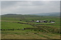
Lane Top Farm
You can also see the ridge continuing on to Cribden.
Image: © Bill Boaden
Taken: 23 Jul 2008
0.01 miles
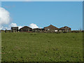
3
Goodshaw Lane
Leads to Lane Top Farm
Image: © Alexander P Kapp
Taken: 16 Mar 2011
0.15 miles
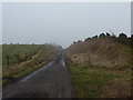
4
Cattle grid and the road to High Withins
Image: © Alexander P Kapp
Taken: 16 Mar 2011
0.24 miles
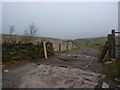
5
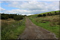
Access Track leading to Higher Withins
Section of the Rossendale Way long distance footpath
Image: © Chris Heaton
Taken: 5 Sep 2018
0.24 miles