IMAGES TAKEN NEAR TO
Broadway, ACCRINGTON, BB5 1EZ
Introduction
This page details the photographs taken nearby to Broadway, BB5 1EZ by members of the Geograph project.
The Geograph project started in 2005 with the aim of publishing, organising and preserving representative images for every square kilometre of Great Britain, Ireland and the Isle of Man.

There are currently over 7.5m images from over14,400 individuals and you can help contribute to the project by visiting https://www.geograph.org.uk
Image Map
Images are licensed for reuse under creativecommons.org/licenses/by-sa/2.0
Notes
- Clicking on the map will re-center to the selected point.
- The higher the marker number, the further away the image location is from the centre of the postcode.
Image Listing (425 Images Found)
Images are licensed for reuse under creativecommons.org/licenses/by-sa/2.0
Image
Details
Distance
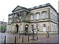
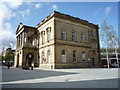
2
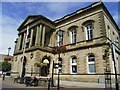
Town Hall.
Built in 1858 in memory of Sir Robert Peel the Prime Minister who was born in the area.
Image: © Stanley Walker
Taken: 14 Aug 2007
0.01 miles
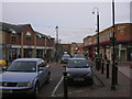
4
Soon to be gone
Woolworths, Accrington
Image: © Alexander P Kapp
Taken: 20 Dec 2008
0.02 miles
6
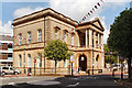
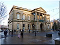
Accrington Town Hall
Accrington Town Hall on Blackburn Road is a Grade II* listed building (http://www.britishlistedbuildings.co.uk/en-183799-town-hall-accrington British Listed Buildings). It was built as Peel Institution 1857-8.
Image: © David Dixon
Taken: 12 May 2012
0.02 miles
8
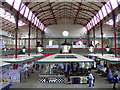
Accrington Market Hall
The refurbishment is almost complete, more photos at
http://www.flickr.com/photos/rossendalewadey/sets/72157624405601540/
Image: © Robert Wade
Taken: 1 Jul 2010
0.03 miles
9
Accrington Town Hall
Built in 1858 in memory of Sir Robert Peel.
Image: © JThomas
Taken: 17 Sep 2018
0.03 miles
10
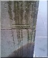
Ordnance Survey Cut Mark
This OS cut mark can be found on the SE angle of the Town Hall. It marks a point 134.3955m above mean sea level.
Image: © Adrian Dust
Taken: 22 Nov 2019
0.03 miles