IMAGES TAKEN NEAR TO
Garden Street, ACCRINGTON, BB5 1DB
Introduction
This page details the photographs taken nearby to Garden Street, BB5 1DB by members of the Geograph project.
The Geograph project started in 2005 with the aim of publishing, organising and preserving representative images for every square kilometre of Great Britain, Ireland and the Isle of Man.

There are currently over 7.5m images from over14,400 individuals and you can help contribute to the project by visiting https://www.geograph.org.uk
Image Map
Images are licensed for reuse under creativecommons.org/licenses/by-sa/2.0
Notes
- Clicking on the map will re-center to the selected point.
- The higher the marker number, the further away the image location is from the centre of the postcode.
Image Listing (93 Images Found)
Images are licensed for reuse under creativecommons.org/licenses/by-sa/2.0
Image
Details
Distance
1
Garden Street, Accrington
A look at the rear entrance to Victoria Hospital.
Image: © Stuart Wilding
Taken: 17 Sep 2014
0.03 miles
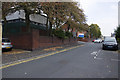
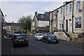
2
Ramsbottom Street, Accrington
The house with the men at the front is number 32, the house next to it on the left is number 36. There is no number 34. Why? I've no idea.
Image: © Stuart Wilding
Taken: 17 Sep 2014
0.03 miles
3
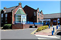
Accrington Victoria Community Hospital
Part of the East Lancashire Hospitals NHS Trust.
Image: © Chris Heaton
Taken: 4 Jul 2018
0.03 miles
4

Ramsbottom Street, Accrington
This house used to be a shop selling bread and cakes in the 1970's.
Image: © Stuart Wilding
Taken: 17 Sep 2014
0.04 miles
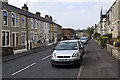
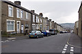
5
Ramsbottom Street, Accrington
Looking east along a typical street in Accrington.
Image: © Stuart Wilding
Taken: 17 Sep 2014
0.04 miles
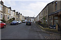
6
Ramsbottom Street, Accrington
Looking west along a typical street in Accrington.
Image: © Stuart Wilding
Taken: 17 Sep 2014
0.05 miles
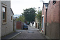
7
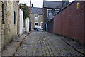
The back of Ramsbottom Street
These back streets are given various names around the country, alley, ginnel etc. When I lived here in the 1970's they were simply known as Backs.
Image: © Stuart Wilding
Taken: 17 Sep 2014
0.05 miles
8
Haywood Road, Accrington
In the 1970's the house on the left was a butchers, whilst next to it was a small general store.
Image: © Stuart Wilding
Taken: 17 Sep 2014
0.05 miles
9
The back of Ramsbottom Street
These back streets are given various names around the country, alley, ginnel etc. When I lived here in the 1970's they were simply known as Backs.
Image: © Stuart Wilding
Taken: 17 Sep 2014
0.05 miles
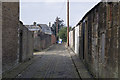
10
Side Street, Accrington
This side street runs from Ramsbottom Street down to Whalley Road.
Image: © Stuart Wilding
Taken: 17 Sep 2014
0.06 miles