IMAGES TAKEN NEAR TO
Rose Street, ACCRINGTON, BB5 0QA
Introduction
This page details the photographs taken nearby to Rose Street, BB5 0QA by members of the Geograph project.
The Geograph project started in 2005 with the aim of publishing, organising and preserving representative images for every square kilometre of Great Britain, Ireland and the Isle of Man.

There are currently over 7.5m images from over14,400 individuals and you can help contribute to the project by visiting https://www.geograph.org.uk
Image Map
Images are licensed for reuse under creativecommons.org/licenses/by-sa/2.0
Notes
- Clicking on the map will re-center to the selected point.
- The higher the marker number, the further away the image location is from the centre of the postcode.
Image Listing (85 Images Found)
Images are licensed for reuse under creativecommons.org/licenses/by-sa/2.0
Image
Details
Distance
5
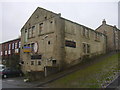
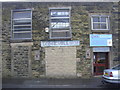
Accrington Old Band Club, Carter Street, Accrington, BB5 0PY
Image: © Robert Wade
Taken: 2 Oct 2009
0.05 miles
6
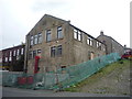
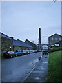
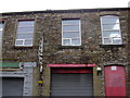
Industrial building on Victoria Street, Accrington
Image: © JThomas
Taken: 10 Sep 2018
0.05 miles
7
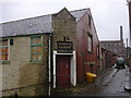
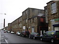
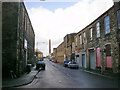
Accrington Old Band Club, Carter Street, Accrington, BB5 0PY
Woodnook mill in background being prepared for demolition
Image: © Robert Wade
Taken: 2 Oct 2009
0.05 miles
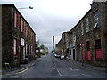
10
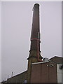
Victoria Mill AD1912, Victoria Street, Accrington
Image: © Robert Wade
Taken: 2 Oct 2009
0.07 miles