IMAGES TAKEN NEAR TO
Worston Close, ACCRINGTON, BB5 0JP
Introduction
This page details the photographs taken nearby to Worston Close, BB5 0JP by members of the Geograph project.
The Geograph project started in 2005 with the aim of publishing, organising and preserving representative images for every square kilometre of Great Britain, Ireland and the Isle of Man.

There are currently over 7.5m images from over14,400 individuals and you can help contribute to the project by visiting https://www.geograph.org.uk
Image Map
Images are licensed for reuse under creativecommons.org/licenses/by-sa/2.0
Notes
- Clicking on the map will re-center to the selected point.
- The higher the marker number, the further away the image location is from the centre of the postcode.
Image Listing (15 Images Found)
Images are licensed for reuse under creativecommons.org/licenses/by-sa/2.0
Image
Details
Distance


3
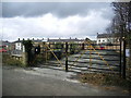
Coal Pit Lane Caravan Site, Oswaldtwistle
Image: © Alexander P Kapp
Taken: 14 Feb 2008
0.18 miles


6
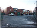
Oswaldtwistle Mill Business and Conference Centre
Image: © Alexander P Kapp
Taken: 11 Jan 2011
0.23 miles
7
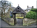
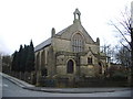
St Mary's Church, Oswaldtwistle, Lychgate
Image: © Alexander P Kapp
Taken: 14 Feb 2008
0.24 miles
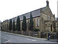
10
St Mary's Church, Oswaldtwistle, War Memorial
Image: © Alexander P Kapp
Taken: 14 Feb 2008
0.24 miles