IMAGES TAKEN NEAR TO
Pickup Street, ACCRINGTON, BB5 0EY
Introduction
This page details the photographs taken nearby to Pickup Street, BB5 0EY by members of the Geograph project.
The Geograph project started in 2005 with the aim of publishing, organising and preserving representative images for every square kilometre of Great Britain, Ireland and the Isle of Man.

There are currently over 7.5m images from over14,400 individuals and you can help contribute to the project by visiting https://www.geograph.org.uk
Image Map
Images are licensed for reuse under creativecommons.org/licenses/by-sa/2.0
Notes
- Clicking on the map will re-center to the selected point.
- The higher the marker number, the further away the image location is from the centre of the postcode.
Image Listing (62 Images Found)
Images are licensed for reuse under creativecommons.org/licenses/by-sa/2.0
Image
Details
Distance
1
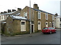
Former Bridge's Bakery, Pickup Street, Church
The name is painted in gold on the rear gable end
Image: © Alexander P Kapp
Taken: 17 Jan 2012
0.04 miles


5
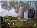
Black Swan
Black Swan, fungus and outfall pipe at Oswaldtwistle Mill Pond.
Image: © Gerald England
Taken: 7 Nov 2006
0.07 miles
6
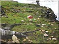
Fungi at Oswaldtwistle
Fungi growing by the pond at Oswaldtwistle Mill. The one in the middle is a fly agaric Image
Image: © Gerald England
Taken: 7 Nov 2006
0.07 miles
7
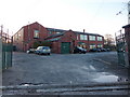
Oswaldtwistle Mill Business and Conference Centre
Image: © Alexander P Kapp
Taken: 11 Jan 2011
0.08 miles
8
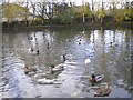
Oswaldtwistle Mill Pond
The pond at Oswaldtwistle Mill.
Image: © Gerald England
Taken: 7 Nov 2006
0.08 miles

10
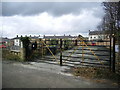
Coal Pit Lane Caravan Site, Oswaldtwistle
Image: © Alexander P Kapp
Taken: 14 Feb 2008
0.09 miles