IMAGES TAKEN NEAR TO
Coach Road, ACCRINGTON, BB5 0ED
Introduction
This page details the photographs taken nearby to Coach Road, BB5 0ED by members of the Geograph project.
The Geograph project started in 2005 with the aim of publishing, organising and preserving representative images for every square kilometre of Great Britain, Ireland and the Isle of Man.

There are currently over 7.5m images from over14,400 individuals and you can help contribute to the project by visiting https://www.geograph.org.uk
Image Map
Images are licensed for reuse under creativecommons.org/licenses/by-sa/2.0
Notes
- Clicking on the map will re-center to the selected point.
- The higher the marker number, the further away the image location is from the centre of the postcode.
Image Listing (166 Images Found)
Images are licensed for reuse under creativecommons.org/licenses/by-sa/2.0
Image
Details
Distance
1
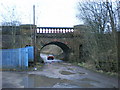
Railway bridge over Coach Road
It is indeed a fancy parapet
Image: © Alexander P Kapp
Taken: 12 Jan 2009
0.01 miles

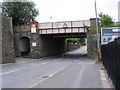
3

Railway bridge over Coach Road, Church
Image: © Alexander P Kapp
Taken: 9 Mar 2011
0.02 miles


8
Church Railway Bridge
The bridge over Market Street next to the Railway Station.
Image: © Gordon Griffiths
Taken: 21 Jun 2009
0.07 miles
9
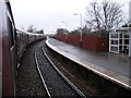
Church and Oswaldtwistle Station
The train is a steam special, "The Cotton Mill Express". View from the train.
Image: © SMJ
Taken: 13 Dec 2008
0.08 miles
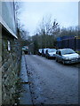
10

Tinker Bridge, Blackburn Road, Church
The bridge is approximately where the nearest car is.
Image: © Alexander P Kapp
Taken: 9 Mar 2011
0.08 miles