IMAGES TAKEN NEAR TO
Alleytroyds, ACCRINGTON, BB5 0DU
Introduction
This page details the photographs taken nearby to Alleytroyds, BB5 0DU by members of the Geograph project.
The Geograph project started in 2005 with the aim of publishing, organising and preserving representative images for every square kilometre of Great Britain, Ireland and the Isle of Man.

There are currently over 7.5m images from over14,400 individuals and you can help contribute to the project by visiting https://www.geograph.org.uk
Image Map
Images are licensed for reuse under creativecommons.org/licenses/by-sa/2.0
Notes
- Clicking on the map will re-center to the selected point.
- The higher the marker number, the further away the image location is from the centre of the postcode.
Image Listing (167 Images Found)
Images are licensed for reuse under creativecommons.org/licenses/by-sa/2.0
Image
Details
Distance
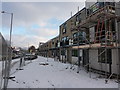
1
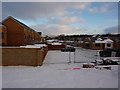
Yeadon Court, Accrington
New development
Image: © Alexander P Kapp
Taken: 2 Dec 2010
0.04 miles
2
Acorn Park, Blackburn Road, Church, Accrington BB5 0DJ
Image: © Robert Wade
Taken: 9 Sep 2010
0.05 miles
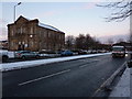
5

Market Street
The B6231 in Church.
Image: © Gordon Griffiths
Taken: 21 Jun 2009
0.06 miles
6
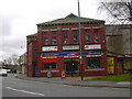
Top Gear Motor Store, Old Church Conservative Club, Market Street
Built as the Conservative Club in 1927.
Image: © Robert Wade
Taken: 8 Apr 2009
0.06 miles
7
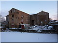
Rear of Hargreaves Warehouse, Church
Image: © Alexander P Kapp
Taken: 2 Dec 2010
0.06 miles
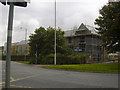
8
Front of Yeadon Court, Accrington
The fronts face onto Blackburn Road, but they are numbered to the road at the rear.
Image: © Alexander P Kapp
Taken: 2 Dec 2010
0.06 miles
9
Blackburn Road joins Market Street in Oswaldwistle
Image: © Raymond Knapman
Taken: 7 Mar 2014
0.06 miles
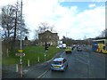
10
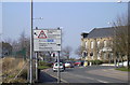
Blackburn Road junction
Baptist Chapel to the right
Image: © Robert Wade
Taken: 19 Mar 2009
0.06 miles