IMAGES TAKEN NEAR TO
Blackburn Road, ACCRINGTON, BB5 0AL
Introduction
This page details the photographs taken nearby to Blackburn Road, BB5 0AL by members of the Geograph project.
The Geograph project started in 2005 with the aim of publishing, organising and preserving representative images for every square kilometre of Great Britain, Ireland and the Isle of Man.

There are currently over 7.5m images from over14,400 individuals and you can help contribute to the project by visiting https://www.geograph.org.uk
Image Map
Images are licensed for reuse under creativecommons.org/licenses/by-sa/2.0
Notes
- Clicking on the map will re-center to the selected point.
- The higher the marker number, the further away the image location is from the centre of the postcode.
Image Listing (112 Images Found)
Images are licensed for reuse under creativecommons.org/licenses/by-sa/2.0
Image
Details
Distance

2
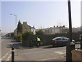
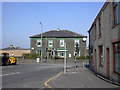
Blackburn Road
The church that was on this corner has been demolished
Image: © Robert Wade
Taken: 19 Mar 2009
0.02 miles
3
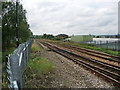
Railway west of Accrington Station
Looking west towards Blackburn
Image: © Alexander P Kapp
Taken: 8 Sep 2008
0.04 miles

7
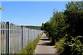
Hyndburn Greenway (1)
Section of Cycle Route No.6 running parallel to the East Lancashire Railway in Accrington
Image: © Chris Heaton
Taken: 4 Jul 2018
0.06 miles
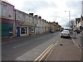
8
Platt Social Club 178 Blackburn Road, Scaitcliffe
Image: © Robert Wade
Taken: 19 Mar 2009
0.06 miles
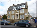
9

Portland Street Community Centre, Accrington
Image: © Alexander P Kapp
Taken: 29 Nov 2010
0.06 miles
