IMAGES TAKEN NEAR TO
Sunnindale Avenue, ROSSENDALE, BB4 9UF
Introduction
This page details the photographs taken nearby to Sunnindale Avenue, BB4 9UF by members of the Geograph project.
The Geograph project started in 2005 with the aim of publishing, organising and preserving representative images for every square kilometre of Great Britain, Ireland and the Isle of Man.

There are currently over 7.5m images from over14,400 individuals and you can help contribute to the project by visiting https://www.geograph.org.uk
Image Map
Images are licensed for reuse under creativecommons.org/licenses/by-sa/2.0
Notes
- Clicking on the map will re-center to the selected point.
- The higher the marker number, the further away the image location is from the centre of the postcode.
Image Listing (18 Images Found)
Images are licensed for reuse under creativecommons.org/licenses/by-sa/2.0
Image
Details
Distance
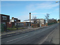
1
Fearns Community Sports College
A comprehensive school which caters for pupils from 11–16.
Image: © JThomas
Taken: 10 Oct 2018
0.15 miles
2
Fearns Community Sports College
Community Sports College at Fearns Moss, Stacksteads.
Image: © Richard Spencer
Taken: 18 Feb 2006
0.16 miles
3
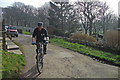
Pennine Bridleway, Edgeside
This is the short section by Woodhead Close that links Wales Road with Edgeside Lane.
Image: © michael ely
Taken: 14 Mar 2012
0.18 miles
5
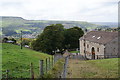
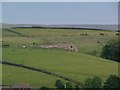
Farm Hill Farm, Edgeside
The centre of Waterfoot is visible in the bottom of the valley.
Image: © Bill Boaden
Taken: 2 Oct 2010
0.20 miles
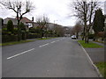
6
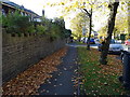
Path beside Booth Road, Waterfoot, Rossendale
Looking north west.
Image: © JThomas
Taken: 10 Oct 2018
0.21 miles
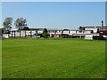
8
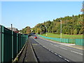
Fearns Moss
Looking north west beside the grounds of Fearns Community Sports College.
Image: © JThomas
Taken: 10 Oct 2018
0.21 miles
10
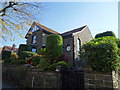
Farm Hill Farm, Edgeside, Waterfoot, Rossendale
Looking from Seat Naze. This hill farm has changed a great deal from its original form. Now looking more like a show home than a farm house. The stone outhouses have been demolished and natural rock which surrounded it has been covered by dry stone.
Image: © Mark Trickett
Taken: 13 Jun 2004
0.22 miles