IMAGES TAKEN NEAR TO
Lumb Lane, ROSSENDALE, BB4 9RW
Introduction
This page details the photographs taken nearby to Lumb Lane, BB4 9RW by members of the Geograph project.
The Geograph project started in 2005 with the aim of publishing, organising and preserving representative images for every square kilometre of Great Britain, Ireland and the Isle of Man.

There are currently over 7.5m images from over14,400 individuals and you can help contribute to the project by visiting https://www.geograph.org.uk
Image Map
Images are licensed for reuse under creativecommons.org/licenses/by-sa/2.0
Notes
- Clicking on the map will re-center to the selected point.
- The higher the marker number, the further away the image location is from the centre of the postcode.
Image Listing (19 Images Found)
Images are licensed for reuse under creativecommons.org/licenses/by-sa/2.0
Image
Details
Distance
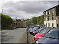
1
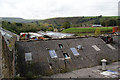
Rooftops at Springvale Works
Most of the works appears occupied though the fabric is not well maintained.
Image: © Bill Boaden
Taken: 2 Oct 2010
0.12 miles
2
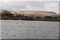
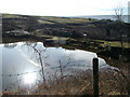
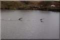
Jack Lodge
The dam wall and the outflow are visible in this photo.
Image: © John Aspden
Taken: 14 Apr 2006
0.14 miles
5
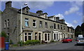
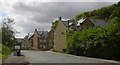
Burnley Road East, Waterfoot, Rossendale
Image: © Robert Wade
Taken: 19 May 2011
0.16 miles
6
Burnley Road East, Waterfoot, Rossendale
Image: © Robert Wade
Taken: 19 May 2011
0.18 miles
7
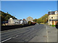
Burnley Road East (B6238)
Looking north east.
Image: © JThomas
Taken: 10 Oct 2018
0.19 miles
8
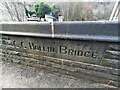
Old Boundary Marker on Hollin Bridge
Bridge Marker set in the northwest parapet of Hollin Bridge, Whitewell Brook, on the B6238 Burnley Road East. In Rossendale District. Inscribed C C HOLLIN BRIDGE.
Milestone Society National ID: LA_RAWTEN06br
Image: © D Phillips
Taken: Unknown
0.19 miles
9
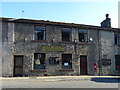
New Houses, Burnley Road East, Waterfoot, Rossendale
Was the abattoir - slaughter house
Image: © Robert Wade
Taken: 19 May 2011
0.20 miles
10
RAOB Social Club
Royal Antediluvian Order of Buffaloes.
On Burnley Road East.
Showing position of Postbox No. BB4 533.
See Image] for postbox.
Image: © JThomas
Taken: 10 Oct 2018
0.20 miles