IMAGES TAKEN NEAR TO
Hargreaves Fold Lane, ROSSENDALE, BB4 9RU
Introduction
This page details the photographs taken nearby to Hargreaves Fold Lane, BB4 9RU by members of the Geograph project.
The Geograph project started in 2005 with the aim of publishing, organising and preserving representative images for every square kilometre of Great Britain, Ireland and the Isle of Man.

There are currently over 7.5m images from over14,400 individuals and you can help contribute to the project by visiting https://www.geograph.org.uk
Image Map
Images are licensed for reuse under creativecommons.org/licenses/by-sa/2.0
Notes
- Clicking on the map will re-center to the selected point.
- The higher the marker number, the further away the image location is from the centre of the postcode.
Image Listing (25 Images Found)
Images are licensed for reuse under creativecommons.org/licenses/by-sa/2.0
Image
Details
Distance
1
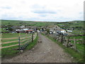
Approaching Hargreaves Fold Farm from the east
Image: © John Slater
Taken: 9 May 2018
0.01 miles
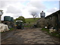
2

Hargreaves Fold
Situated above Lumb, this appears to be bigger than just a farm.
Image: © Bill Boaden
Taken: 14 Jun 2008
0.02 miles
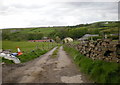
4

Hargreaves Fold in snow
Hargreaves Fold is the group of buildings nearest the camera.
Image: © John Aspden
Taken: Unknown
0.03 miles
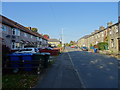
6
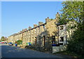
Terraced housing on Burnley Road East (B6238)
Image: © JThomas
Taken: 10 Oct 2018
0.15 miles
7
Burnley Road East (B6238)
Looking north east.
Image: © JThomas
Taken: 10 Oct 2018
0.16 miles
8
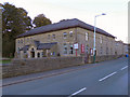
Lumb Baptist Church, Burnley Road East
http://www.lumbbaptist.co.uk/ church website
Image: © David Dixon
Taken: 7 Oct 2010
0.16 miles
9
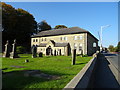
Lumb Baptist Church
On Burnley Road East (B6238).
Image: © JThomas
Taken: 10 Oct 2018
0.17 miles
10
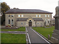
Lumb Baptist Church
On Burnley Road East.
http://www.lumbbaptist.co.uk/ church website
Image: © David Dixon
Taken: 7 Oct 2010
0.17 miles