IMAGES TAKEN NEAR TO
Dean Lane, ROSSENDALE, BB4 9RB
Introduction
This page details the photographs taken nearby to Dean Lane, BB4 9RB by members of the Geograph project.
The Geograph project started in 2005 with the aim of publishing, organising and preserving representative images for every square kilometre of Great Britain, Ireland and the Isle of Man.

There are currently over 7.5m images from over14,400 individuals and you can help contribute to the project by visiting https://www.geograph.org.uk
Image Map
Images are licensed for reuse under creativecommons.org/licenses/by-sa/2.0
Notes
- Clicking on the map will re-center to the selected point.
- The higher the marker number, the further away the image location is from the centre of the postcode.
Image Listing (6 Images Found)
Images are licensed for reuse under creativecommons.org/licenses/by-sa/2.0
Image
Details
Distance
1
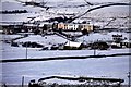
Dean Lane in snow
The terrace of houses in the centre is part of Dean Lane. The walled enclosure in the foreground are the ruins of Grime Bridge colliery.
Image: © John Aspden
Taken: Unknown
0.01 miles
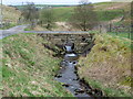
3
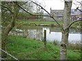
Roadside Pond
Off Dean Lane, Water. Probably a former mill pond.
Image: © John H Darch
Taken: 9 Apr 2014
0.10 miles
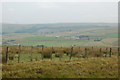
4
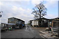
Turn Hill Farm
There is provision here for keeping horses and dogs.
Image: © Bill Boaden
Taken: 8 Jan 2011
0.22 miles