IMAGES TAKEN NEAR TO
All Saints Close, ROSSENDALE, BB4 8QQ
Introduction
This page details the photographs taken nearby to All Saints Close, BB4 8QQ by members of the Geograph project.
The Geograph project started in 2005 with the aim of publishing, organising and preserving representative images for every square kilometre of Great Britain, Ireland and the Isle of Man.

There are currently over 7.5m images from over14,400 individuals and you can help contribute to the project by visiting https://www.geograph.org.uk
Image Map
Images are licensed for reuse under creativecommons.org/licenses/by-sa/2.0
Notes
- Clicking on the map will re-center to the selected point.
- The higher the marker number, the further away the image location is from the centre of the postcode.
Image Listing (60 Images Found)
Images are licensed for reuse under creativecommons.org/licenses/by-sa/2.0
Image
Details
Distance
3
Village Police Station, Crawshawbooth
Now in private ownership
Image: © Robert Wade
Taken: 14 Jul 2011
0.09 miles
4
"Goodshaw Kindergarten" Goodshaw Avenue, Rossendale, Lancashire BB4 8BY
Image: © Robert Wade
Taken: 14 Jul 2011
0.09 miles
5
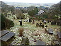
St Mary & All Saints Church, Goodshaw, Graveyard
Image: © Alexander P Kapp
Taken: 3 Feb 2010
0.11 miles
6
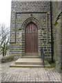
St Mary & All Saints Church, Goodshaw, Doorway
Image: © Alexander P Kapp
Taken: 3 Feb 2010
0.11 miles
7
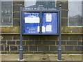
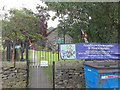
St Mary & All Saints Church, Goodshaw, Sign
Image: © Alexander P Kapp
Taken: 3 Feb 2010
0.11 miles
8

St. Mary & All Saints, Goodshaw
A Church of England parish church.
Image: © philandju
Taken: 23 Apr 2014
0.11 miles
9
St Mary & All Saints Church, Goodshaw, Graveyard
Image: © Alexander P Kapp
Taken: 3 Feb 2010
0.11 miles
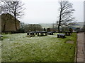
10
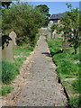
St Mary and All Saints Church, Goodshaw Chapel, Path
Image: © Alexander P Kapp
Taken: 14 May 2008
0.11 miles