IMAGES TAKEN NEAR TO
Bonfire Hill Road, ROSSENDALE, BB4 8PG
Introduction
This page details the photographs taken nearby to Bonfire Hill Road, BB4 8PG by members of the Geograph project.
The Geograph project started in 2005 with the aim of publishing, organising and preserving representative images for every square kilometre of Great Britain, Ireland and the Isle of Man.

There are currently over 7.5m images from over14,400 individuals and you can help contribute to the project by visiting https://www.geograph.org.uk
Image Map (Loading...)


Getting Data...Please wait
Leaflet Map data © OpenStreetMap
Images are licensed for reuse under creativecommons.org/licenses/by-sa/2.0
Notes
- Clicking on the map will re-center to the selected point.
- The higher the marker number, the further away the image location is from the centre of the postcode.
Image Listing (121 Images Found)
Images are licensed for reuse under creativecommons.org/licenses/by-sa/2.0
Image
Details
Distance
1

Roofing pitches, valleys and hips - Crawshawbooth
Roofing study
Image: © Richard Johnson
Taken: 9 Jul 2010
0.03 miles


7

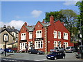
The White Bull, Crawshawbooth
On Burnley Road.
Image: © JThomas
Taken: 25 Sep 2018
0.07 miles
10
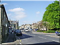
Burnley Road, Crawshawbooth, Lancashire A682
Image: © Robert Wade
Taken: 14 Jul 2011
0.08 miles