IMAGES TAKEN NEAR TO
Kershaw Close, ROSSENDALE, BB4 8DR
Introduction
This page details the photographs taken nearby to Kershaw Close, BB4 8DR by members of the Geograph project.
The Geograph project started in 2005 with the aim of publishing, organising and preserving representative images for every square kilometre of Great Britain, Ireland and the Isle of Man.

There are currently over 7.5m images from over14,400 individuals and you can help contribute to the project by visiting https://www.geograph.org.uk
Image Map
Images are licensed for reuse under creativecommons.org/licenses/by-sa/2.0
Notes
- Clicking on the map will re-center to the selected point.
- The higher the marker number, the further away the image location is from the centre of the postcode.
Image Listing (135 Images Found)
Images are licensed for reuse under creativecommons.org/licenses/by-sa/2.0
Image
Details
Distance
1
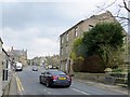
Burnley Road, Crawshawbooth
The town's main street.
Image: © philandju
Taken: 23 Apr 2014
0.01 miles
2
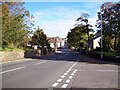
Crawshawbooth, Lancashire
The A682 into Crawshawbooth as seen from St John's church. This used to be the main road between Manchester and Burnley and prior to the opening of the M66 was in constant use by heavy traffic.
Image: © Len Williams
Taken: 14 Oct 2012
0.01 miles
3
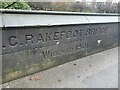
Old Boundary Marker on Rakefoot Bridge
Bridge Marker in the western parapet of Rakefoot Bridge, Limy Water, Crawshawbooth, on the A682 Burnley Road. Inscribed C C RAKEFOOT BRIDGE / WIDENED 1901.
Milestone Society National ID: LA_RAWTEN09br
Image: © D Phillips
Taken: 18 Dec 2020
0.01 miles
4
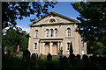
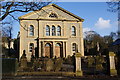
Crawshawbooth: Former Methodist Church
This is the former Rakefoot Wesleyan Methodist Church, no longer used for religious purposes. Presumably the Methodists found that the upkeep of this large church was too expensive, so they moved round the corner to the York Street premises. Just when this move took place, I do not know.
I am indebted to Richard Hoare for help with this image.
Image: © Dr Neil Clifton
Taken: 9 Jun 2011
0.03 miles
5
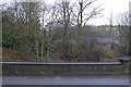
Rakefoot Bridge over Limy Water, Crawshawbooth, Lancashire
Image: © Robert Wade
Taken: 25 Feb 2010
0.03 miles
6
Former Methodist Chapel, Crawshawbooth
Now part of a flats development, and from the outside it has recaptured something of its former glory.
Image: © Bill Boaden
Taken: 20 Feb 2010
0.03 miles
7
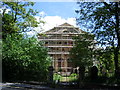
Ex-Wesleyan Methodist Church
In the process of being converted into flats
Image: © Alexander P Kapp
Taken: 29 May 2007
0.03 miles
8
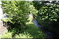
Crawshawbooth: Limy Water
Seen looking downstream from the bridge on the A682. Limy Water is a tributary of the River Irwell, which it joins at Waterfoot.
Image: © Dr Neil Clifton
Taken: 9 Jun 2011
0.03 miles
9
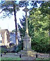
War Memorial, Crawshawbooth
The Crawshawbooth War Memorial is located just off the A682.
Image: © Len Williams
Taken: 14 Oct 2012
0.03 miles
10
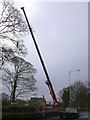
War Memorial being moved
Local firm Killalea moving the War Memorial from the churchyard, where it was in danger of being washed away, to the East side of Burnley Road at Rakefoot
Image: © Robert Wade
Taken: 25 Feb 2010
0.03 miles