IMAGES TAKEN NEAR TO
Greenbank Park, ROSSENDALE, BB4 7SY
Introduction
This page details the photographs taken nearby to Greenbank Park, BB4 7SY by members of the Geograph project.
The Geograph project started in 2005 with the aim of publishing, organising and preserving representative images for every square kilometre of Great Britain, Ireland and the Isle of Man.

There are currently over 7.5m images from over14,400 individuals and you can help contribute to the project by visiting https://www.geograph.org.uk
Image Map
Images are licensed for reuse under creativecommons.org/licenses/by-sa/2.0
Notes
- Clicking on the map will re-center to the selected point.
- The higher the marker number, the further away the image location is from the centre of the postcode.
Image Listing (190 Images Found)
Images are licensed for reuse under creativecommons.org/licenses/by-sa/2.0
Image
Details
Distance
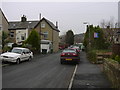
4
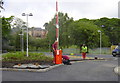
New Staff Car Park for the Health Hub
The "old" Health Centre has been demolished and is now a staff car park for the new health hub on the opposite side of Bacup Road a new pedestrian crossing has now been installed to prevent them getting run over
Image: © Robert Wade
Taken: 29 Jun 2010
0.10 miles
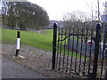
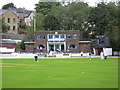
7
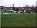
Rawtenstall Cricket Club
Rawtenstall CC's Worswick Memorial Ground.
Image: © BatAndBall
Taken: 21 Mar 2012
0.12 miles

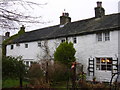
10
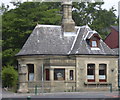
Gate-Lodge House Bacup Road Rawtenstall
Now a private home
Image: © Robert Wade
Taken: 10 Jun 2007
0.13 miles