IMAGES TAKEN NEAR TO
Edge Lane, ROSSENDALE, BB4 7SS
Introduction
This page details the photographs taken nearby to Edge Lane, BB4 7SS by members of the Geograph project.
The Geograph project started in 2005 with the aim of publishing, organising and preserving representative images for every square kilometre of Great Britain, Ireland and the Isle of Man.

There are currently over 7.5m images from over14,400 individuals and you can help contribute to the project by visiting https://www.geograph.org.uk
Image Map
Images are licensed for reuse under creativecommons.org/licenses/by-sa/2.0
Notes
- Clicking on the map will re-center to the selected point.
- The higher the marker number, the further away the image location is from the centre of the postcode.
Image Listing (30 Images Found)
Images are licensed for reuse under creativecommons.org/licenses/by-sa/2.0
Image
Details
Distance
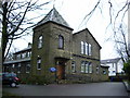
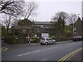
4
Sion Baptist Church, Cloughfold
It looks like they have sold off the manse.
Image: © Bill Boaden
Taken: 13 Feb 2010
0.05 miles
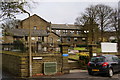
5
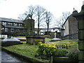
Sion Baptist Church, Cloughfold, Graveyard
Image: © Alexander P Kapp
Taken: 20 Feb 2008
0.05 miles
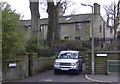
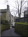
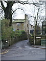
10
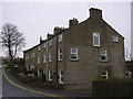
Cottages, Newchurch Road, Higher Cloughfold
Image: © Robert Wade
Taken: 19 Dec 2008
0.08 miles